IMAGES TAKEN NEAR TO
Price Street, TREDEGAR, NP22 5HQ
Introduction
This page details the photographs taken nearby to Price Street, NP22 5HQ by members of the Geograph project.
The Geograph project started in 2005 with the aim of publishing, organising and preserving representative images for every square kilometre of Great Britain, Ireland and the Isle of Man.

There are currently over 7.5m images from over14,400 individuals and you can help contribute to the project by visiting https://www.geograph.org.uk
Image Map
Images are licensed for reuse under creativecommons.org/licenses/by-sa/2.0
Notes
- Clicking on the map will re-center to the selected point.
- The higher the marker number, the further away the image location is from the centre of the postcode.
Image Listing (138 Images Found)
Images are licensed for reuse under creativecommons.org/licenses/by-sa/2.0
Image
Details
Distance
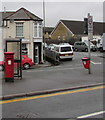
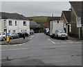
1
Price Street, Rhymney
From the B4257 along Price Street towards Church Street.
Image: © Jaggery
Taken: 12 Dec 2018
0.01 miles
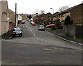
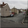
2
Price Street, Rhymney
Looking to the SSW along Price Street towards Queen's Crescent in April 2019.
The red car near the camera is alongside the former post office seen here https://www.geograph.org.uk/photo/3871445 in January 2014.
Image: © Jaggery
Taken: 5 Apr 2019
0.01 miles
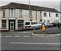
3
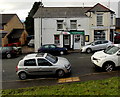
Upper High Street Post Office, Rhymney
Located a few tens of metres south of Upper High Street, at 21 Price Street.
Image: © Jaggery
Taken: 17 Jan 2014
0.02 miles
4
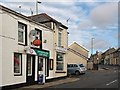
Upper High Street Post Office, Rhymney
Situated in Price Street at the junction with Upper High Street.
Image: © Robin Drayton
Taken: 5 Mar 2014
0.02 miles
5
Queen Elizabeth II pillarbox on a Rhymney corner
Alongside a BT phonebox on the corner of Price Street and Church Street.
Image: © Jaggery
Taken: 5 Apr 2019
0.02 miles
6
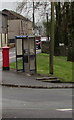
BT phonebox on a Rhymney corner
Alongside a pillarbox on the corner of Price Street and Church Street.
Image: © Jaggery
Taken: 5 Apr 2019
0.02 miles
7
Oasis on a Rhymney corner
Oasis hair & beauty salon is on the corner of Price Street and King Edward Terrace. Viewed across the B4257.
Image: © Jaggery
Taken: 5 Apr 2019
0.02 miles
8
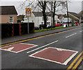
Ysgol/School warning sign, Church Street, Rhymney
The Welsh/English sign is near speed bumps across the B4257 Church Street on the approach to Upper Rhymney Primary School.
Image: © Jaggery
Taken: 5 Apr 2019
0.03 miles
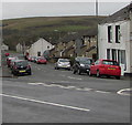
9
King Edward Terrace, Rhymney
Looking west along King Edward Terrace across the B4257 from Kings Avenue.
The 30mph speed limit drops to 20 on the approach to Upper Rhymney Primary School. https://www.geograph.org.uk/photo/3939923
Image: © Jaggery
Taken: 5 Apr 2019
0.03 miles
10
North along Price Street, Rhymney
The corner of Queen's Crescent is on the left.
Image: © Jaggery
Taken: 12 Dec 2018
0.03 miles