IMAGES TAKEN NEAR TO
The Terrace, TREDEGAR, NP22 5DZ
Introduction
This page details the photographs taken nearby to The Terrace, NP22 5DZ by members of the Geograph project.
The Geograph project started in 2005 with the aim of publishing, organising and preserving representative images for every square kilometre of Great Britain, Ireland and the Isle of Man.

There are currently over 7.5m images from over14,400 individuals and you can help contribute to the project by visiting https://www.geograph.org.uk
Image Map
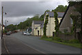
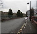
Images are licensed for reuse under creativecommons.org/licenses/by-sa/2.0
Notes
- Clicking on the map will re-center to the selected point.
- The higher the marker number, the further away the image location is from the centre of the postcode.
Image Listing (289 Images Found)
Images are licensed for reuse under creativecommons.org/licenses/by-sa/2.0
Image
Details
Distance
1

Redwood Memorial Hospital, Rhymney
The hospital was named when the National Health Service was inaugurated in 1948. Lewis Redwood and his son Thomas both held the post of Medical Officer of the Rhymney Iron Works.
Image: © Robin Drayton
Taken: 23 May 2012
0.01 miles
2

Houses on the northeast side of The Terrace, Rhymney
The houses are opposite sports courts.
Image: © Jaggery
Taken: 12 Dec 2018
0.01 miles
3

Manest Street Rhymney
Manest Street heads away from High Street.
Image: © Jaggery
Taken: 7 May 2010
0.01 miles


6

Accept guide dogs, Rhymney
The notice is on a gate at the entrance from The Terrace to a recreation area.
The text is STRICTLY NO DOGS ALLOWED. Accept Guide Dogs.
Though the meaning is clear, probably Except Guide Dogs was intended.
Image: © Jaggery
Taken: 17 Jan 2014
0.02 miles
7
The Terrace, Rhymney
The cream-coloured building on the right is the Brewery Club
Image: © Robert Eva
Taken: 9 Jun 2017
0.02 miles
8
The Terrace, Rhymney
Sports courts are on the left. Houses https://www.geograph.org.uk/photo/6000216 are on the right.
Image: © Jaggery
Taken: 12 Dec 2018
0.03 miles
9

Manest Street electricity substation, Rhymney
The Western Power Distribution electricity substation is in a fenced enclosure alongside the path from Manest Street to Surgery Hill. The substation identifier is MANEST ST. RHYMNEY S/S 552382
Image: © Jaggery
Taken: 12 Dec 2018
0.04 miles
10
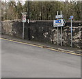
Signs alongside Surgery Hill, Rhymney
The sign on the left shows No vehicles heavier than 7.5 tonnes except for access.
The signs is the middle point towards Rhymney railway station Park & Ride and Maerdy Industrial Estate.
The small signs on the right are for National Cycle Network Route 468.
Image: © Jaggery
Taken: 12 Dec 2018
0.05 miles