IMAGES TAKEN NEAR TO
Heol Uchaf, TREDEGAR, NP22 5DN
Introduction
This page details the photographs taken nearby to Heol Uchaf, NP22 5DN by members of the Geograph project.
The Geograph project started in 2005 with the aim of publishing, organising and preserving representative images for every square kilometre of Great Britain, Ireland and the Isle of Man.

There are currently over 7.5m images from over14,400 individuals and you can help contribute to the project by visiting https://www.geograph.org.uk
Image Map
Images are licensed for reuse under creativecommons.org/licenses/by-sa/2.0
Notes
- Clicking on the map will re-center to the selected point.
- The higher the marker number, the further away the image location is from the centre of the postcode.
Image Listing (44 Images Found)
Images are licensed for reuse under creativecommons.org/licenses/by-sa/2.0
Image
Details
Distance
1

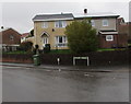
Susannah Houses, Rhymney
These houses are scheduled for conservation.
Dating from the early 19th century, they are Grade II listed as a rare surviving example of early industrial housing in S Wales, little altered, and for their associations with the important Rhymney Iron Company.
Susannah was the sister of the local ironmaster, Richard Crawshay.
Image: © Robin Drayton
Taken: 7 Apr 2012
0.10 miles
2
Susannah Houses, Rhymney
Another view of these 200 year old houses http://www.geograph.org.uk/photo/2930445 .
Image: © Robin Drayton
Taken: 7 Apr 2012
0.11 miles
3
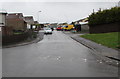
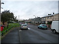
Aneurin Terrace houses, Rhymney
Viewed across speed bumps.
Image: © Jaggery
Taken: 5 Apr 2019
0.11 miles
4
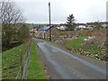
Unnamed road ascending from Aneurin Terrace, Rhymney
Towards residential streets named Is-Fryn, Heol-y-Twyn and Heol Uchaf.
Image: © Jaggery
Taken: 5 Apr 2019
0.12 miles
5
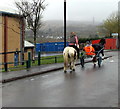
Horse rider and sulky rider, Aneurin Terrace, Rhymney
A sulky is a light two-wheeled horse-drawn vehicle for one person.
Image: © Jaggery
Taken: 5 Apr 2019
0.12 miles
6
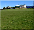
Houses on top of a steep grassy bank, Rhymney
Ael-y-bryn houses viewed from the B4257.
Image: © Jaggery
Taken: 11 Apr 2019
0.12 miles
7
Aneurin Terrace houses, Rhymney
This northern part of Rhymney is c320 metres (about 1,050 ft) above mean sea level.
Image: © Jaggery
Taken: 5 Apr 2019
0.13 miles
8
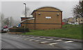
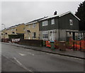
Southeast side of Ael-y-bryn Community Centre near Rhymney
Viewed across the B4257. The bilingual name sign on the wall shows that
Ael-y-bryn Community Centre is Canolfan Gymunedol Ael-y-bryn in Welsh.
Image: © Jaggery
Taken: 5 Apr 2019
0.13 miles
9
Part of Aneurin Terrace, Rhymney
Houses in colours that maybe used to reflect the valley; grey, brown, green. Reminding me of Max Boyce's 'Rhondda Grey'.
Image: © Jeremy Bolwell
Taken: 16 Sep 2012
0.14 miles
10
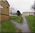
Path junction in the north of Rhymney
The path on the right ascends from the B4257 to Aneurin Terrace.
The edge of Ael-y-bryn Community Centre https://www.geograph.org.uk/photo/6110999 is on the left.
Image: © Jaggery
Taken: 5 Apr 2019
0.14 miles