IMAGES TAKEN NEAR TO
Arthur Street, TREDEGAR, NP22 5AW
Introduction
This page details the photographs taken nearby to Arthur Street, NP22 5AW by members of the Geograph project.
The Geograph project started in 2005 with the aim of publishing, organising and preserving representative images for every square kilometre of Great Britain, Ireland and the Isle of Man.

There are currently over 7.5m images from over14,400 individuals and you can help contribute to the project by visiting https://www.geograph.org.uk
Image Map
Images are licensed for reuse under creativecommons.org/licenses/by-sa/2.0
Notes
- Clicking on the map will re-center to the selected point.
- The higher the marker number, the further away the image location is from the centre of the postcode.
Image Listing (103 Images Found)
Images are licensed for reuse under creativecommons.org/licenses/by-sa/2.0
Image
Details
Distance

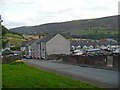
2
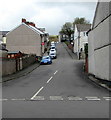
Hill Road, Abertysswg
Ascending from Charles Street to Barkley Street and Arthur Street.
Image: © Jaggery
Taken: 25 Apr 2019
0.05 miles
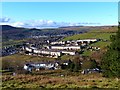
3
Abertysswg
The village is within the South Wales Coalfield and used to have a pit at the end of Westville, although the mine closed in 1969.
Image: © Alan Hughes
Taken: 17 Jul 2024
0.06 miles
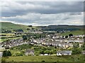
4
Abertysswg
Looking down onto Abertysswg from the Coed Cefn-rhychdir road.
Image: © Sally Lloyd
Taken: 22 Jul 2007
0.06 miles
5
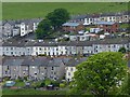
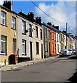
Terraced houses, Abertysswg
Abertysswg (Abertyswg in Welsh) was a mining village established at the end of the 19th century at the time of the sinking of McLaren colliery.
The colliery closed in 1959.
Viewed across Cwm Tyswg.
Image: © Robin Drayton
Taken: 29 May 2014
0.06 miles
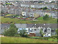
6
Hill Road, Abertysswg
Looking across the Rhymney Valley.
Image: © Robin Drayton
Taken: 8 Oct 2008
0.06 miles
7
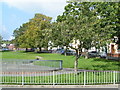
Arthur Street houses, Abertysswg
From the northern edge of The Green, Arthur Street ascends towards Hill Road and Greensway.
Image: © Jaggery
Taken: 4 May 2019
0.07 miles
9
Overlooking Abertysswg
Pontlottyn is in the distance on the far side of the Rhymney Valley.
Image: © Robin Drayton
Taken: 22 Nov 2013
0.08 miles
10
![Arthur Street, Abertysswg [1]](https://s1.geograph.org.uk/geophotos/01/00/21/1002117_19e0eee3_120x120.jpg)
Arthur Street, Abertysswg [1]
Built at the end of the 19th century, this was one of the earliest streets in Abertysswg.
Image: © Robin Drayton
Taken: 8 Oct 2008
0.08 miles