IMAGES TAKEN NEAR TO
Crown Business Park, TREDEGAR, NP22 4XD
Introduction
This page details the photographs taken nearby to Crown Business Park, NP22 4XD by members of the Geograph project.
The Geograph project started in 2005 with the aim of publishing, organising and preserving representative images for every square kilometre of Great Britain, Ireland and the Isle of Man.

There are currently over 7.5m images from over14,400 individuals and you can help contribute to the project by visiting https://www.geograph.org.uk
Image Map
Images are licensed for reuse under creativecommons.org/licenses/by-sa/2.0
Notes
- Clicking on the map will re-center to the selected point.
- The higher the marker number, the further away the image location is from the centre of the postcode.
Image Listing (19 Images Found)
Images are licensed for reuse under creativecommons.org/licenses/by-sa/2.0
Image
Details
Distance
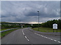
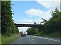
2
A465 improvements looking eastwards
Taken from the access bridge to Dukestown Cemetery, Tredegar.
The new road will diverge to the north from the existing A465. The area is currently being filled with earth that is being compacted to form the foundation for the new road.
Image: © Robin Drayton
Taken: 20 Nov 2013
0.15 miles
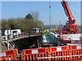
3
A465 improvements, Dukestown (6)
Construction of a new Cemetery Road bridge over the A465.
A large concrete block is being slowly lowered and positioned on the side of the bridge.
For another view of this operation see http://www.geograph.org.uk/photo/3937610 .
Image: © Robin Drayton
Taken: 16 Apr 2014
0.18 miles
4
A465 improvements, Dukestown (5)
Construction of a new Cemetery Road bridge over the A465.
The existing bridge on the left will be demolished.
See http://www.geograph.org.uk/photo/3880338 for this site one month earlier.
Image: © Robin Drayton
Taken: 16 Apr 2014
0.18 miles
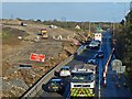
5

A465 improvements, Dukestown (4)
Construction of an abutment for the new Cemetery Road bridge.
The existing bridge over the A465 (from which this picture is taken) is to be replaced by a new bridge which will span the widened carriageway just to the west.
This picture shows work on the southern abutment of the new bridge. The reinforced concrete has set and a crane is lifting one of the formwork panels away from the abutment. More formwork on the left remains to be removed.
Image: © Robin Drayton
Taken: 5 Mar 2014
0.18 miles
6
Crown Avenue bridge near Dukestown
The bridge leads to a cemetery and farm from Dukestown (to the right/south)
Image: © David Smith
Taken: 7 Jul 2011
0.18 miles
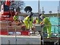
7
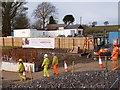
Considerate constructors care about appearance
Workers on the site of the dualling of the A465 Heads of the Valleys road at Dukestown, Tredegar.
Image: © Robin Drayton
Taken: 14 Jan 2014
0.20 miles
8
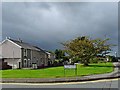
Twyn Star, Dukestown, Tredegar
This was the area where the earliest Chartist lodge was formed in 1839.
In May 1839 a rally of almost 5000 people gathered in a nearby field.
One of the leaders of the Chartists lived nearby http://www.geograph.org.uk/photo/3191009.
A memorial to some of those who died in the uprising is situated near to the bus stop on the right.
Image: © Robin Drayton
Taken: 3 Oct 2012
0.20 miles
9
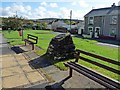
Chartist Memorial at Twyn Star, Dukestown
Bilingual memorial to three Chartists who were killed in Newport during the uprising of 1839 http://www.geograph.org.uk/photo/3191442 .
For information on the local Chartists see http://www.geograph.org.uk/photo/3191171 .
For a contemporary report of the event see http://www.newportpast.com/nfs/strands/frost/report.htm .
Image: © Robin Drayton
Taken: 3 Oct 2012
0.20 miles
10
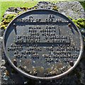
Chartist Memorial (detail)
http://www.geograph.org.uk/photo/3191425
Image: © Robin Drayton
Taken: 3 Oct 2012
0.20 miles