IMAGES TAKEN NEAR TO
Princess Court, TREDEGAR, NP22 4PZ
Introduction
This page details the photographs taken nearby to Princess Court, NP22 4PZ by members of the Geograph project.
The Geograph project started in 2005 with the aim of publishing, organising and preserving representative images for every square kilometre of Great Britain, Ireland and the Isle of Man.

There are currently over 7.5m images from over14,400 individuals and you can help contribute to the project by visiting https://www.geograph.org.uk
Image Map
Images are licensed for reuse under creativecommons.org/licenses/by-sa/2.0
Notes
- Clicking on the map will re-center to the selected point.
- The higher the marker number, the further away the image location is from the centre of the postcode.
Image Listing (88 Images Found)
Images are licensed for reuse under creativecommons.org/licenses/by-sa/2.0
Image
Details
Distance

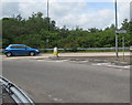
2
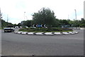
Town Centre Roundabout in Tredegar
At the junction of the A4048 and an unnamed road to the town centre.
Image: © Jaggery
Taken: 1 Jun 2017
0.06 miles
3
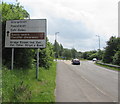
North along the A4048, Tredegar
Signs on the right show ahead along the A4048 for Merthyr Tydfil and Abergavenny.
Nearer locations ahead are Sirhowy, Ashvale, Dukestown Industrial Estates.
Image: © Jaggery
Taken: 1 Jun 2017
0.06 miles
4
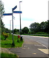
Path and cycleway signpost alongside the A4048, Tredegar
Left along National Cycle Network Route 411 for Harford Gardens.
Right along National Cycle Network Route 411 for the town centre.
Image: © Jaggery
Taken: 1 Jun 2017
0.06 miles
5
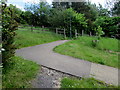
Footpath and cycleway to Harford Gardens, Tredegar
Part of National Cycle Network Route 411 viewed from the edge of the A4048.
Image: © Jaggery
Taken: 1 Jun 2017
0.06 miles
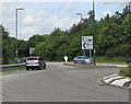
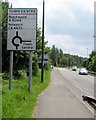
6
Direction sign facing the A4048, Tredegar
On the approach to Town Centre Roundabout.
Image: © Jaggery
Taken: 1 Jun 2017
0.07 miles
7
Tredegar town centre this way
At the edge of the A4048 junction, the black arrow on the sign on the right
points left along an unnamed road to Stockton Way and Commercial Street.
Image: © Jaggery
Taken: 1 Jun 2017
0.07 miles
8
Directions sign on the approach to Town Centre Roundabout, Tredegar
Alongside the A4048.
Image: © Jaggery
Taken: 1 Jun 2017
0.08 miles
9
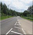
From 40 to the National Speed Limit on the A4048, Tredegar
South of Town Centre Roundabout, the 40 mph speed limit increases to the National Speed Limit ahead.
Image: © Jaggery
Taken: 1 Jun 2017
0.09 miles
10
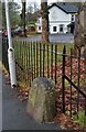
Boundary Stone
Boundary Stone with 'S 1818' carved on the front.
Image: © Adrian Dust
Taken: 5 Dec 2020
0.09 miles