IMAGES TAKEN NEAR TO
James Street, TREDEGAR, NP22 4JE
Introduction
This page details the photographs taken nearby to James Street, NP22 4JE by members of the Geograph project.
The Geograph project started in 2005 with the aim of publishing, organising and preserving representative images for every square kilometre of Great Britain, Ireland and the Isle of Man.

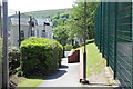
There are currently over 7.5m images from over14,400 individuals and you can help contribute to the project by visiting https://www.geograph.org.uk
Image Map
Images are licensed for reuse under creativecommons.org/licenses/by-sa/2.0
Notes
- Clicking on the map will re-center to the selected point.
- The higher the marker number, the further away the image location is from the centre of the postcode.
Image Listing (37 Images Found)
Images are licensed for reuse under creativecommons.org/licenses/by-sa/2.0
Image
Details
Distance
1
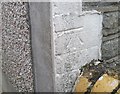
Ordnance Survey Cut Mark
This OS cut mark can be found on No16 James Street. It marks a point 291.822m above mean sea level.
Image: © Adrian Dust
Taken: 27 Aug 2018
0.01 miles
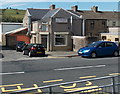
2
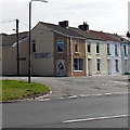
Park Place Florist, Tredegar
The shop is at 1 Glyn Terrace, on the corner of Lower Rawlinson Terrace.
Image: © Jaggery
Taken: 5 Sep 2013
0.05 miles
3
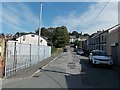
Lower Rawlinson Terrace, Tredegar
Viewed from Glyn Terrace looks towards Poplar Road. Some references name this street Rawlinson Terrace, but the name sign shows Lower Rawlinson Terrace, to distinguish these houses from the row of seven houses in Rawlinson Terrace, a separately-named part of Poplar Road between James Street and Woodfield Road.
Image: © Jaggery
Taken: 5 Sep 2013
0.06 miles
4
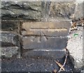
Ordnance Survey Cut Mark
This OS cut mark can be found on the wall NE side of Poplar Road. It marks a point 292.852m above mean sea level.
Image: © Adrian Dust
Taken: 27 Aug 2018
0.07 miles
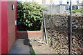
5
Pedestrian entrance to Georgetown School, Tredegar
Entrance from Poplar Road to rear of Georgetown Primary School, Tredegar. The green fencing borders an outside games area behind the school building.
Image: © M J Roscoe
Taken: 24 May 2016
0.08 miles
6
Happy Gathering, Tredegar
Chinese takeaway and fish & chips, located at 60 Vale Terrace.
Image: © Jaggery
Taken: 5 Sep 2013
0.08 miles
7
Future wildlife area, Georgetown School, Tredegar
In this unused strip of land on the edge of Georgetown Primary School, a Gwent Wildlife Trust working party have just constructed a small pond and planted wildflowers.
Image: © M J Roscoe
Taken: 24 May 2016
0.09 miles
8
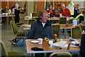
Checkpoint 9B on the Valleys 100
It's 10-30am on Sunday and after walking over 55 miles in non-stop rain in the last 24 hours this walker is composing himself for the next 45 miles. He's just had a cooked meal and a can of beer and just about to roll a cigarette. Now who said walking was good for your health?
Image: © Ian S
Taken: 25 May 2014
0.10 miles
9
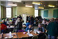
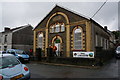
Checkpoint 9B, Georgetown, Tredegar
Georgetown Community Centre is the breakfast stop on the LDWA 2014 Valleys 100.
Image: © Ian S
Taken: 25 May 2014
0.10 miles
10
Checkpoint 9B, Georgetown, Tredegar
Georgetown Community Centre is the breakfast stop on the LDWA 2014 Valleys 100.
Image: © Ian S
Taken: 25 May 2014
0.10 miles