IMAGES TAKEN NEAR TO
The Promenade, TREDEGAR, NP22 4HR
Introduction
This page details the photographs taken nearby to The Promenade, NP22 4HR by members of the Geograph project.
The Geograph project started in 2005 with the aim of publishing, organising and preserving representative images for every square kilometre of Great Britain, Ireland and the Isle of Man.

There are currently over 7.5m images from over14,400 individuals and you can help contribute to the project by visiting https://www.geograph.org.uk
Image Map
Images are licensed for reuse under creativecommons.org/licenses/by-sa/2.0
Notes
- Clicking on the map will re-center to the selected point.
- The higher the marker number, the further away the image location is from the centre of the postcode.
Image Listing (213 Images Found)
Images are licensed for reuse under creativecommons.org/licenses/by-sa/2.0
Image
Details
Distance
1
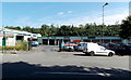
Promenade Motor Company, Tredegar
Used car business, servicing, tyres, MoTs etc, viewed across the B4256 Promenade d'Orvault.
Image: © Jaggery
Taken: 5 Sep 2013
0.02 miles
2
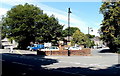
Two Promenade d'Orvault junctions in Tredegar
Viewed across the B4256 Promenade d'Orvault.
Shop Row is on the right, Lower Coronation Street is on the left.
Image: © Jaggery
Taken: 5 Sep 2013
0.04 miles
3
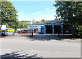
Parker Motors Garage, Tredegar
Garage and MoT test centre, viewed across the B4256 Promenade d'Orvault.
Image: © Jaggery
Taken: 5 Sep 2013
0.04 miles
4
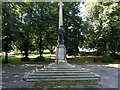
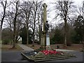
Tredegar War Memorial
Located at the eastern edge of Bedwellty Park, the War Memorial was unveiled on December 14th, 1924. The dedication on the side in view is TO THE GLORY OF GOD AND THE IMMORTAL MEMORY OF THE MEN OF TREDEGAR WHO FELL IN THE GREAT WAR 1914-1918. THEY FELL THAT WE MIGHT LIVE. Below the original dedication is ALSO WORLD WAR 1939-1945.
A nearby information board records that more than 4,000 men from the town fought in the Great War (now usually known as the First World War). Many volunteered to escape working in the coal mine. They believed the fighting would be over within months. Instead they were away for years. Many never came home : more than 300 Tredegar men were killed, a devastating loss for a town of its size.
The memorial was rededicated after the Second World War. Men from Tredegar had fought a fierce campaign in Burma, which led to one battle site there being named Tredegar Hill.
Image: © Jaggery
Taken: 5 Sep 2013
0.05 miles
5
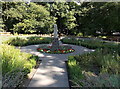
Garden of Remembrance, Bedwellty Park, Tredegar
Located near Bedwellty House, http://www.geograph.org.uk/photo/3639254 the Garden of Remembrance is dedicated
to all who have died as a result of war, tyranny and oppression.
Image: © Jaggery
Taken: 5 Sep 2013
0.06 miles
6
M & L Motorcycles, Tredegar
Motorbike sales, spares, service and repairs shop at 19 Morgan Street, viewed looking away from the town centre.
Image: © Jaggery
Taken: 5 Sep 2013
0.06 miles
7
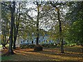
Bedwellty House through the trees, Tredegar
Taken through the park railings alongside the Promenade d`Orvault which is on the eastern side of the park.
Tredegar has been twinned with Orvault, a town in Brittany, since 1979.
Image: © Robin Drayton
Taken: 1 Nov 2012
0.07 miles
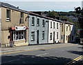
8
Lower Coronation Street, Tredegar
Lower Coronation Street descends towards Morgan Street.
Double yellow lines on both sides of the road indicate no parking at any time.
Image: © Jaggery
Taken: 23 May 2017
0.07 miles
9
War memorial, Bedwellty Park, Tredegar
Erected in 1924.
It is said to be unique in showing a soldier presenting arms.
Image: © Robin Drayton
Taken: 18 Feb 2009
0.07 miles
10
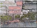
Ordnance Survey Cut Mark
This OS cut mark can be found on the Park Wall SW side of Morgan Street. It marks a point 295.470m above mean sea level.
Image: © Adrian Dust
Taken: 27 Aug 2018
0.07 miles