IMAGES TAKEN NEAR TO
Waterworks Lane, TREDEGAR, NP22 4EP
Introduction
This page details the photographs taken nearby to Waterworks Lane, NP22 4EP by members of the Geograph project.
The Geograph project started in 2005 with the aim of publishing, organising and preserving representative images for every square kilometre of Great Britain, Ireland and the Isle of Man.

There are currently over 7.5m images from over14,400 individuals and you can help contribute to the project by visiting https://www.geograph.org.uk
Image Map
Images are licensed for reuse under creativecommons.org/licenses/by-sa/2.0
Notes
- Clicking on the map will re-center to the selected point.
- The higher the marker number, the further away the image location is from the centre of the postcode.
Image Listing (36 Images Found)
Images are licensed for reuse under creativecommons.org/licenses/by-sa/2.0
Image
Details
Distance
3
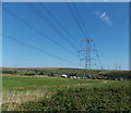
Power lines and pylons east of Trefil Road, Nant-y-Bwch
Image: © Jaggery
Taken: 22 Aug 2013
0.12 miles
4
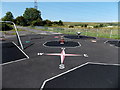
Cardinal points of the compass on a children's playground, Nant-y-Bwch
The playground is set back 50 metres from Trefil Road. My Garmin confirmed that the compass points on the ground are correctly positioned, so it was easy to know the direction of view when submitting this photo. I wondered what children's game makes use of the cardinal points...
Image: © Jaggery
Taken: 22 Aug 2013
0.12 miles
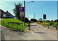
5
Up Trefil Road, Tredegar
Trefil Road ascents towards the small village of Trefil Image
Image: © Jaggery
Taken: 17 Jul 2019
0.14 miles
6
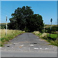
Disused road NE of Trefil Road, Nant-y-Bwch
Faded 30mph speed limit signs suggest that it is a long time since this was the through road shown on old maps.
Image: © Jaggery
Taken: 22 Aug 2013
0.14 miles
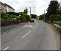
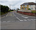
7
Traffic calming along Trefil Road opposite Tynewydd
Traffic ahead has priority over oncoming traffic past the short section of narrowed roadway.
The sign on the left shows 52-60 Tynewydd.
Image: © Jaggery
Taken: 22 Aug 2013
0.15 miles
8
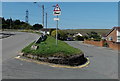
Risk of grounding warning sign, Nant-y-Bwch, Tredegar
Located at a junction near The Mountain Air. http://www.geograph.org.uk/photo/3960019
The sign depicts an articulated lorry grounded on an exaggeratedly undulating road.
The left fork leads to the village of Trefil. The right fork is for Nant-y-Bwch water treatment works.
Image: © Jaggery
Taken: 22 Aug 2013
0.15 miles
9
Up Waundeg, Tredegar
From the junctions of Llwyn Helyg (left side) and Trefil Road,
the road named Waundeg ascends into the Waundeg area of Tredegar.
Image: © Jaggery
Taken: 17 Jul 2019
0.15 miles
10
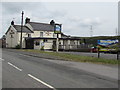
The Mountain Air, Tredegar
Llwyn Helyg side of the pub on the corner of Golwg-y-Mynydd.
Image: © Jaggery
Taken: 17 Jul 2019
0.15 miles