IMAGES TAKEN NEAR TO
Scwrfa Road, TREDEGAR, NP22 4DU
Introduction
This page details the photographs taken nearby to Scwrfa Road, NP22 4DU by members of the Geograph project.
The Geograph project started in 2005 with the aim of publishing, organising and preserving representative images for every square kilometre of Great Britain, Ireland and the Isle of Man.

There are currently over 7.5m images from over14,400 individuals and you can help contribute to the project by visiting https://www.geograph.org.uk
Image Map
Images are licensed for reuse under creativecommons.org/licenses/by-sa/2.0
Notes
- Clicking on the map will re-center to the selected point.
- The higher the marker number, the further away the image location is from the centre of the postcode.
Image Listing (26 Images Found)
Images are licensed for reuse under creativecommons.org/licenses/by-sa/2.0
Image
Details
Distance
1
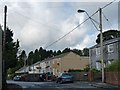
Police Row, Dukestown, Tredegar
The Chartist leader Zephaniah Williams lived at no. 10.
He was leader of the local Chartists who marched to Newport in November 1839.
This led to a number of the Chartists being shot and killed by soldiers.
He was convicted for high treason and sentenced to death by hanging, drawing and quartering but this was later commuted to transportation to Australia.
Image
Image
Image
Image
Image: © Robin Drayton
Taken: 3 Oct 2012
0.02 miles
2
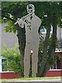
Jack the Fifer at Twyn Star, Dukestown, Tredegar
John Rees 'Jack the Fifer' (1815-1893).
For more on the life of Jack the Fifer and the Chartist Uprising see "The Man from the Alamo" by John Humphries.
The inscription reads:
John Rees, better known as Jack the fifer (a fife was a small high-pitched flute), was a mason by trade. He was heavily involved in the Chartist Rising of 1839. In 1835 jack fought in the Texan War of independence before returning to Wales.
It was his military experience in having been part of an ill-equipped group of fighters that captured San Antonio from regular Mexican soldiers that led him to be chosen to lead the Chartist attack, on the Westgate Hotel in Newport, at the head of a column of Tredegar pikemen and gunmen. At 7pm on 3rd November 1839 an estimated 5 to 6,000 men had assembled here, at Twyn-y-Star, ready for the march to Newport via Ebbw Vale. The attack on the Westgate ended in failure but Jack evaded capture and escaped to Texas where he re-joined the army before heading west to California to join the gold rush.
The Chartist lodge in Dukestown was the oldest in the Sirhowy Valley; here, Zephaniah Williams lived before moving to Blaina in early 1839. Its headquarters was the Star Inn, (Twyn-y-Star) . Many meetings of the rebel command were held here during 1839 before the rising and the Star field (now built over) was the site of one of the largest public gatherings anywhere in Wales during the 19th century. On 12th August 1839, Chartist speakers called upon Queen Victoria to dissolve Parliament and accept the People's Charter as the basis for electing a new Government for the country.
Image: © Robin Drayton
Taken: 2 Aug 2013
0.03 miles
3
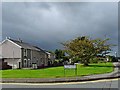
Twyn Star, Dukestown, Tredegar
This was the area where the earliest Chartist lodge was formed in 1839.
In May 1839 a rally of almost 5000 people gathered in a nearby field.
One of the leaders of the Chartists lived nearby http://www.geograph.org.uk/photo/3191009.
A memorial to some of those who died in the uprising is situated near to the bus stop on the right.
Image: © Robin Drayton
Taken: 3 Oct 2012
0.04 miles
4
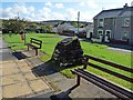
Chartist Memorial at Twyn Star, Dukestown
Bilingual memorial to three Chartists who were killed in Newport during the uprising of 1839 http://www.geograph.org.uk/photo/3191442 .
For information on the local Chartists see http://www.geograph.org.uk/photo/3191171 .
For a contemporary report of the event see http://www.newportpast.com/nfs/strands/frost/report.htm .
Image: © Robin Drayton
Taken: 3 Oct 2012
0.04 miles
5
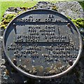
Chartist Memorial (detail)
http://www.geograph.org.uk/photo/3191425
Image: © Robin Drayton
Taken: 3 Oct 2012
0.04 miles
6
Heritage trail marker, Twyn Star, Dukestown, Tredegar
The trail marker for John Rees 'Jack the Fifer', who was one of the leaders of the Chartist Uprising in 1839, is on the right http://www.geograph.org.uk/photo/3613034 .
The Chartist Memorial is on the left http://www.geograph.org.uk/photo/3191425 .
Image: © Robin Drayton
Taken: 2 Aug 2013
0.04 miles
7
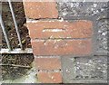
Ordnance Survey Cut Mark
This OS cut mark can be found on the wall of Merion House, St Lukes Road. It marks a point 336.685m above mean sea level.
Image: © Adrian Dust
Taken: 27 Aug 2018
0.04 miles
8
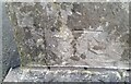
Ordnance Survey Cut Mark
This OS cut mark can be found on the east angle of the RC Church. It marks a point 319.504m above mean sea level.
Image: © Adrian Dust
Taken: 5 Dec 2020
0.14 miles
10
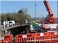
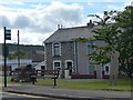
A465 improvements, Dukestown (5)
Construction of a new Cemetery Road bridge over the A465.
The existing bridge on the left will be demolished.
See http://www.geograph.org.uk/photo/3880338 for this site one month earlier.
Image: © Robin Drayton
Taken: 16 Apr 2014
0.18 miles