IMAGES TAKEN NEAR TO
Golwg-y-Mynydd, TREDEGAR, NP22 4DH
Introduction
This page details the photographs taken nearby to Golwg-y-Mynydd, NP22 4DH by members of the Geograph project.
The Geograph project started in 2005 with the aim of publishing, organising and preserving representative images for every square kilometre of Great Britain, Ireland and the Isle of Man.

There are currently over 7.5m images from over14,400 individuals and you can help contribute to the project by visiting https://www.geograph.org.uk
Image Map
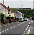
Images are licensed for reuse under creativecommons.org/licenses/by-sa/2.0
Notes
- Clicking on the map will re-center to the selected point.
- The higher the marker number, the further away the image location is from the centre of the postcode.
Image Listing (55 Images Found)
Images are licensed for reuse under creativecommons.org/licenses/by-sa/2.0
Image
Details
Distance
1
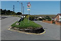
Risk of grounding warning sign, Nant-y-Bwch, Tredegar
Located at a junction near The Mountain Air. http://www.geograph.org.uk/photo/3960019
The sign depicts an articulated lorry grounded on an exaggeratedly undulating road.
The left fork leads to the village of Trefil. The right fork is for Nant-y-Bwch water treatment works.
Image: © Jaggery
Taken: 22 Aug 2013
0.04 miles
2
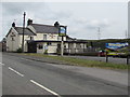
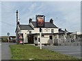
The Mountain Air, Tredegar
Llwyn Helyg side of the pub on the corner of Golwg-y-Mynydd.
Image: © Jaggery
Taken: 17 Jul 2019
0.04 miles
3
The Mountain Air, Nant-y-Bwch, Tredegar
Viewed across Llwyn Helyg. The name sign shows The Mountain Air LOCAL PUB AND DINING.
Image: © Jaggery
Taken: 22 Aug 2013
0.04 miles
4
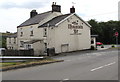
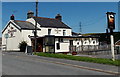
The Mountain Air local pub & dining, Tredegar
The Golwg-y-Mynydd side of the pub on the corner of Llwyn Helyg.
Image: © Jaggery
Taken: 17 Jul 2019
0.04 miles
5
Mountain Air Inn, Nantybwch, Tredegar
Formerly a farmhouse built in 1885.
The sign shows a nearby viaduct http://www.geograph.org.uk/photo/3147065 .
Image: © Robin Drayton
Taken: 6 Sep 2012
0.04 miles
6
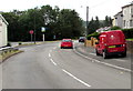
Royal Mail van, Llwyn Helyg, Tredegar
Parked while its driver delivers letters and small parcels to nearby houses.
The identifier T10 on the back on the van shows that it is based at Tredegar delivery office.
Image: © Jaggery
Taken: 17 Jul 2019
0.05 miles
7
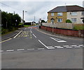
Up Waundeg, Tredegar
From the junctions of Llwyn Helyg (left side) and Trefil Road,
the road named Waundeg ascends into the Waundeg area of Tredegar.
Image: © Jaggery
Taken: 17 Jul 2019
0.06 miles
8
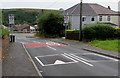
From 20 to 30, Waundeg, Tredegar
The 20mph speed limit on Waundeg increases to 30mph
on the approach to the Trefil Road/Llwyn Helyg junctions.
Image: © Jaggery
Taken: 17 Jul 2019
0.06 miles
9
Down Waundeg, Tredegar
The road named Waundeg descends towards the Trefil Road/Llwyn Helyg junctions.
Image: © Jaggery
Taken: 17 Jul 2019
0.06 miles
10
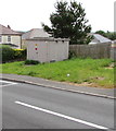
Western Power Distribution electricity substation, Waundeg, Tredegar
The grey cabinet alongside the road named Waundeg is a Western Power Distribution electricity substation.
Its identifier is TYNEWYDD DUKESTOWN S/S 551434
Image: © Jaggery
Taken: 17 Jul 2019
0.06 miles