IMAGES TAKEN NEAR TO
Ystrad Deri, TREDEGAR, NP22 4DE
Introduction
This page details the photographs taken nearby to Ystrad Deri, NP22 4DE by members of the Geograph project.
The Geograph project started in 2005 with the aim of publishing, organising and preserving representative images for every square kilometre of Great Britain, Ireland and the Isle of Man.

There are currently over 7.5m images from over14,400 individuals and you can help contribute to the project by visiting https://www.geograph.org.uk
Image Map
Images are licensed for reuse under creativecommons.org/licenses/by-sa/2.0
Notes
- Clicking on the map will re-center to the selected point.
- The higher the marker number, the further away the image location is from the centre of the postcode.
Image Listing (3 Images Found)
Images are licensed for reuse under creativecommons.org/licenses/by-sa/2.0
Image
Details
Distance
1
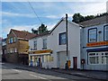
Former Truck Shop, Dukestown Road, Tredegar
This was the Company Shop for the Sirhowy Ironworks http://www.geograph.org.uk/photo/2943096 where employees were paid with tokens or notes which could only be spent in the company shop.
This system, which led to abuse by the employers, was made illegal by the 1831 Truck Act but it took until 1887 until it applied to all workers.
Image: © Robin Drayton
Taken: 13 Sep 2012
0.20 miles
3
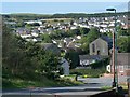
Scwfra, Dukestown, Tredegar
This view is looking towards the west. The chapels are Carmel Welsh Baptist on the right and Ebenezer Independent to the left.
Scwfra means scouring, referring to an early method of getting at mineral deposits by releasing a flood of water to wash away the soil. Here, the mineral deposits were iron ore.
The following is an extract from A History of Monmouthshire, Vol 5, by Sir J A Bradney, published by the South Wales Record Society. The full document can be accessed via http://welshjournals.llgc.org.uk/ .
The oldest process was to scratch on the surface for the mineral but as the mineral got deeper in the earth it was necessary to drive several holes with a bar till a large piece of stratum would fall. A pond would be constructed so that the dam could be cut through and the water allowed to rush over the material separating the mine from the rubbish. This was called scouring, in Welsh ysgwrio, which word survives in the place name Scwrfa.
Image: © Robin Drayton
Taken: 13 Sep 2012
0.20 miles