IMAGES TAKEN NEAR TO
TREDEGAR, NP22 4BS
Introduction
This page details the photographs taken nearby to NP22 4BS by members of the Geograph project.
The Geograph project started in 2005 with the aim of publishing, organising and preserving representative images for every square kilometre of Great Britain, Ireland and the Isle of Man.

There are currently over 7.5m images from over14,400 individuals and you can help contribute to the project by visiting https://www.geograph.org.uk
Image Map
Images are licensed for reuse under creativecommons.org/licenses/by-sa/2.0
Notes
- Clicking on the map will re-center to the selected point.
- The higher the marker number, the further away the image location is from the centre of the postcode.
Image Listing (11 Images Found)
Images are licensed for reuse under creativecommons.org/licenses/by-sa/2.0
Image
Details
Distance
1
Bus stops near Pochin Villas north of Hollybush
Viewed across the A4048 Newport Road near Pochin Villas. http://www.geograph.org.uk/photo/3548870
The dark green shelter is on the side used by buses on route 56 from Tredegar to Newport.
Image: © Jaggery
Taken: 6 Jul 2013
0.03 miles
2
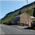
Pochin Villas north of Hollybush
Viewed across the A4048 Newport Road.
At the edge of the row of 3 houses, a sign shows POCHIN VILLAS.
Image: © Jaggery
Taken: 6 Jul 2013
0.04 miles
3
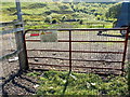
Fish with care north of Hollybush
The notice on a gate at the A4048 Newport Road side of this pond http://www.geograph.org.uk/photo/3548799 shows
DANGER (next to a black triangle with a symbol of a person lying on the ground, struck down by a zigzag bolt (of electricity) )
LOOK UP AND LOOK OUT FOR
OVERHEAD ELECTRIC POWER LINES
ALWAYS CARRY RODS/POLES AT A LOW
LEVEL AND PARALLEL TO THE GROUND
FISH WITH CARE
Image: © Jaggery
Taken: 6 Jul 2013
0.04 miles
4
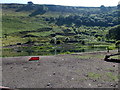
Pond north of Hollybush
The pond is on the west side of the A4048 Newport Road, near a disused quarry.
Image: © Jaggery
Taken: 6 Jul 2013
0.05 miles
5
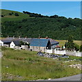
Pochin Houses north of Hollybush
Set back from the A4048 Newport Road.
Image: © Jaggery
Taken: 6 Jul 2013
0.07 miles
6
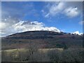
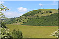
View towards Cruglwyn
Across the Sirhowy valley.
Image: © Alan Hughes
Taken: 24 Feb 2024
0.11 miles
7
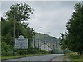
SE boundary sign for Blaenau Gwent north of Hollybush
Viewed along the A4048 Newport Road. The boundary sign http://www.geograph.org.uk/photo/3549915 for the neighbouring Caerphilly County Borough Council is a couple of hundred metres behind the camera, so presumably the actual boundary is somewhere in between.
Blaenau Gwent is a county borough in South Wales, and is also the name of a parliamentary constituency with similar boundaries. Its largest towns are Abertillery, Brynmawr, Ebbw Vale and Tredegar.
Image: © Jaggery
Taken: 6 Jul 2013
0.13 miles
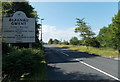
8
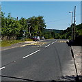
The A4048 looking north
The A4048 is the main road along the Sirhowy Valley from Blackwood to Tredegar. This sign is about 250 metres inside the Unitary Authority boundary between Caerphilly and Blaenau Gwent.
The sign states, in Welsh and English, that Blaenau Gwent is the home of the National Eisteddfod of Wales 2010.
For the view looking south see http://www.geograph.org.uk/photo/1991350 .
Image: © Robin Drayton
Taken: 30 Jul 2010
0.16 miles
9
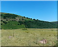
Towards Coed Fedwgwaith across the Sirhowy Valley
Upper Sirhowy Valley from the A4048 near the county boundary. The wind turbine is on the side of Cruglwyn.
Image: © M J Roscoe
Taken: 3 Jun 2016
0.22 miles
10
Coed Fedwgwaith near Hollybush
A view from the A4048 Newport Road looking towards the dark green hillside wood Coed Fedwgwaith.
Image: © Jaggery
Taken: 6 Jul 2013
0.24 miles