IMAGES TAKEN NEAR TO
Stable Lane, TREDEGAR, NP22 4BH
Introduction
This page details the photographs taken nearby to Stable Lane, NP22 4BH by members of the Geograph project.
The Geograph project started in 2005 with the aim of publishing, organising and preserving representative images for every square kilometre of Great Britain, Ireland and the Isle of Man.

There are currently over 7.5m images from over14,400 individuals and you can help contribute to the project by visiting https://www.geograph.org.uk
Image Map
Images are licensed for reuse under creativecommons.org/licenses/by-sa/2.0
Notes
- Clicking on the map will re-center to the selected point.
- The higher the marker number, the further away the image location is from the centre of the postcode.
Image Listing (79 Images Found)
Images are licensed for reuse under creativecommons.org/licenses/by-sa/2.0
Image
Details
Distance
1
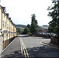
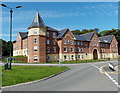
Stable Lane, Tredegar
This part of Stable Lane is between new housing http://www.geograph.org.uk/photo/3639069 on the left
and the entrance to Tredegar Comprehensive School and Leisure Centre on the right.
Image: © Jaggery
Taken: 5 Sep 2013
0.05 miles
2
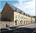
Southern edge of St James Parade, Tredegar
Viewed across Stable Lane. St James Parade http://www.geograph.org.uk/photo/3639056 is a recently-built
housing development near the SE corner of Bedwellty Park.
Image: © Jaggery
Taken: 5 Sep 2013
0.05 miles
3
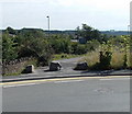
Boulders across a path from Stable Lane, Tredegar
Viewed across Stable Lane. Three boulders prevent cars or lorries using the path.
Image: © Jaggery
Taken: 5 Sep 2013
0.05 miles
4
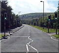
Former railway route now the A4048, Tredegar
Looking south along the A4048 from the near the Bedwellty Park roundabout.
The road here runs parallel with the Sirhowy River, which flows behind the trees and bushes on the left. Old maps show that this used to be the route of a railway, and that the photo was taken near or perhaps in the site of Tredegar railway station. Passenger services in this area ceased in 1960.
Image: © Jaggery
Taken: 5 Sep 2013
0.07 miles
5
St James Parade, Tredegar
Recently-built housing viewed across Stable Lane, near the SE corner of Bedwellty Park.
Image: © Jaggery
Taken: 5 Sep 2013
0.09 miles
6

Nisa Local and Georgetown post office, Tredegar
Viewed across Park Place.
Image: © Jaggery
Taken: 5 Sep 2013
0.10 miles
7
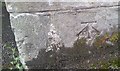
Ordnance Survey Cut Mark
This OS cut mark can be found on the gatepost of the Promenade Gate of Bedwellty Park. It marks a point 288.173m above mean sea level.
Image: © Adrian Dust
Taken: 27 Aug 2018
0.11 miles
8
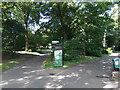
Information board in Bedwellty Park, Tredegar
Located near this entrance. http://www.geograph.org.uk/photo/3639143
Image: © Jaggery
Taken: 5 Sep 2013
0.11 miles
9
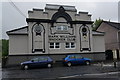
Mark Williams Snooker Club, Vale Terrace, Georgetown
Image: © Ian S
Taken: 24 May 2014
0.11 miles
10
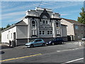
Mark Williams Snooker Club, Tredegar
Previously named Tredegar Snooker Centre, this building in Park Place has been Mark Williams Snooker Club since 2010. It is owned by Mark Williams MBE, a Welsh professional snooker player. He was World Snooker Champion twice, in 2000 and 2003.
Image: © Jaggery
Taken: 5 Sep 2013
0.11 miles