IMAGES TAKEN NEAR TO
Glanhowy Street, TREDEGAR, NP22 4AN
Introduction
This page details the photographs taken nearby to Glanhowy Street, NP22 4AN by members of the Geograph project.
The Geograph project started in 2005 with the aim of publishing, organising and preserving representative images for every square kilometre of Great Britain, Ireland and the Isle of Man.

There are currently over 7.5m images from over14,400 individuals and you can help contribute to the project by visiting https://www.geograph.org.uk
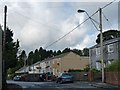
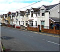
Image Map
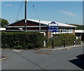
Images are licensed for reuse under creativecommons.org/licenses/by-sa/2.0
Notes
- Clicking on the map will re-center to the selected point.
- The higher the marker number, the further away the image location is from the centre of the postcode.
Image Listing (109 Images Found)
Images are licensed for reuse under creativecommons.org/licenses/by-sa/2.0
Image
Details
Distance
1
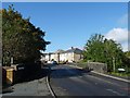
Pont y Widw, Dukestown, Tredegar
This bridge crosses the River Sirhowy.
On the right is an information board and signpost for a walk to Image
Image: © Robin Drayton
Taken: 3 Oct 2012
0.09 miles
2
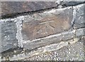
Ordnance Survey Cut Mark
This OS cut mark can be found on the north parapet of the River Sirhowy Bridge. It marks a point 327.642m above mean sea level.
Image: © Adrian Dust
Taken: 27 Aug 2018
0.10 miles
3
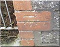
Ordnance Survey Cut Mark
This OS cut mark can be found on the wall of Merion House, St Lukes Road. It marks a point 336.685m above mean sea level.
Image: © Adrian Dust
Taken: 27 Aug 2018
0.12 miles
4
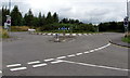
A4048 roundabout near Ashvale, Tredegar
The 30mph speed limit increases to 40mph on the approach
from Ashvale to the roundabout in the middle of the A4048.
Image: © Jaggery
Taken: 7 Aug 2019
0.15 miles
5
Police Row, Dukestown, Tredegar
The Chartist leader Zephaniah Williams lived at no. 10.
He was leader of the local Chartists who marched to Newport in November 1839.
This led to a number of the Chartists being shot and killed by soldiers.
He was convicted for high treason and sentenced to death by hanging, drawing and quartering but this was later commuted to transportation to Australia.
Image
Image
Image
Image
Image: © Robin Drayton
Taken: 3 Oct 2012
0.16 miles
6
Houses on the north side of Ashvale, Tredegar
Houses alongside the road named Ashvale in the Ashvale area of Tredegar.
Image: © Jaggery
Taken: 7 Aug 2019
0.16 miles
7
St Joseph's Catholic Primary School, Tredegar
The school is set back from the east side of Ashvale, near Merthyr Road.
Image: © Jaggery
Taken: 22 Aug 2013
0.16 miles
8
East along Ashvale, Tredegar
Looking east along the road named Ashvale towards the A4048 in the Ashvale area of Tredegar.
The road here is about 335 metres (1,100 ft) above mean sea level.
Image: © Jaggery
Taken: 19 Jul 2019
0.16 miles
9
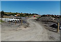
Widening of the A465 Heads of the Valleys Road, Tredegar
At the August 2013 date of the view from Station Road, major engineering work was in progress on widening the A465 Heads of the Valleys Road from three lanes to four lanes (dual carriageway with 2 lanes each way). Work on this section of the A465 from the nearby Nant-y-bwch roundabout to Intermediate Road Bridge near Brynmawr began in 2012 and is scheduled for completion in 2015.
Image: © Jaggery
Taken: 22 Aug 2013
0.16 miles
10
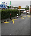
Zigzag yellow markings near a school entrance, Ashvale, Tredegar
Marking the Keep Clear Zone (no parking or stopping)
near the entrance to St Joseph's Catholic Primary School.
Image: © Jaggery
Taken: 19 Jul 2019
0.17 miles