IMAGES TAKEN NEAR TO
Glen View, TREDEGAR, NP22 3SA
Introduction
This page details the photographs taken nearby to Glen View, NP22 3SA by members of the Geograph project.
The Geograph project started in 2005 with the aim of publishing, organising and preserving representative images for every square kilometre of Great Britain, Ireland and the Isle of Man.

There are currently over 7.5m images from over14,400 individuals and you can help contribute to the project by visiting https://www.geograph.org.uk
Image Map
Images are licensed for reuse under creativecommons.org/licenses/by-sa/2.0
Notes
- Clicking on the map will re-center to the selected point.
- The higher the marker number, the further away the image location is from the centre of the postcode.
Image Listing (106 Images Found)
Images are licensed for reuse under creativecommons.org/licenses/by-sa/2.0
Image
Details
Distance
1
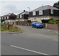
Highfield Close houses, Tredegar
Viewed across the road named Llwyn Helyg.
Image: © Jaggery
Taken: 17 Jul 2019
0.04 miles
3
Bush Bach, Tredegar
Cul-de-sac with a hybrid English/Welsh name on the east side of Llwyn Helyg.
Image: © Jaggery
Taken: 17 Jul 2019
0.04 miles
4

Semis above Llwyn Helyg, Tredegar
Four semi-detached houses above the west side of the road name Llwyn Helyg.
Image: © Jaggery
Taken: 17 Jul 2019
0.05 miles
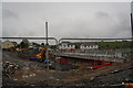
5
A465 improvements, Nantybwch roundabout (8)
The eastern bridge of the new roundabout (on the right).
Image: © Robin Drayton
Taken: 23 Jan 2014
0.06 miles
6
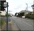
Bush Bach bus stop, Llwyn Helyg, Tredegar
In July 2019 the bus stop sign shows Route E12. Buses on Harris Coaches
Route 20 from Rhymney railway station to Tredegar bus station also stop here.
Image: © Jaggery
Taken: 17 Jul 2019
0.06 miles
7
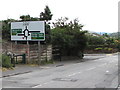
A465 and A4048 directions sign, Llwyn Helyg, Tredegar
On the approach to a major junction on the A465 Heads of the Valleys Road.
Image: © Jaggery
Taken: 17 Jul 2019
0.06 miles
8
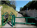
Barrier across a cycle route and footpath, Nant-y-Bwch, Tredegar
The barrier on the east side of Llwyn Helyg prevents vehicular misuse of this footpath and cycleway.
The blue sign alongside the wall shows that this is part of National Cycle Network route 46.
Along this route it's 3 miles to Ebbw Vale, 5 to Brynmawr and 12 to Abergavenny.
Image: © Jaggery
Taken: 22 Aug 2013
0.06 miles
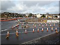
9
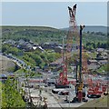
A465 improvements, Nantybwch roundabout (2)
For an earlier picture of this site see http://www.geograph.org.uk/photo/3376856 .
Image: © Robin Drayton
Taken: 7 Jun 2013
0.06 miles
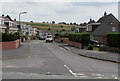
10
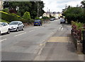
Up Llwyn Helyg, Tredegar
The road named Llwyn Helyg ascends to the NNW past the Bush Bach junction https://www.geograph.org.uk/photo/6214079 on the right.
Image: © Jaggery
Taken: 17 Jul 2019
0.06 miles