1
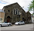
Saron Independent Chapel Tredegar
Image: © Andrew Davis
Taken: 25 Jun 2005
0.03 miles
2
Saron Independent Chapel
Saron Independent (Congregational) Chapel together with the attached schoolroom is a Grade II listed building. The existing building is dated 1858, although the original chapel was built in 1819. Front walls and railings have a separate Grade II listing.
Saron (Sharon) is a biblical place name as recorded in Song of Solomon 2:1 "I am the rose of Sharon".
Image: © Robin Drayton
Taken: 27 Sep 2007
0.07 miles
3
West side of Harcourt Terrace, Tredegar
Row of houses alongside the B4256. The edge of a Grade II listed derelict chapel http://www.geograph.org.uk/photo/5405135 is on the right.
Image: © Jaggery
Taken: 23 May 2017
0.07 miles
4
Saron Congregational Church, Park Row, Tredegar
In May 2017, the name on the church information board behind the car is Saron Congregational Church.
The pediment http://www.geograph.org.uk/photo/5405191 shows SARON INDEPENDENT CHAPEL BUILT 1858.
The building was Grade II listed in 1999.
Image: © Jaggery
Taken: 23 May 2017
0.08 miles
5
Derelict Grade II listed former chapel, Harcourt Terrace, Tredegar
The former Harcourt Terrace Wesleyan Methodist Chapel viewed in May 2017. The Cadw website records that the building which was erected in the late 19th century was remodelled in the early 20th century. The schoolroom on the right dates from 1883. The first chapel was built in 1825 as an English Wesleyan chapel for English people arriving to work at the Tredegar ironworks. The building was Grade II listed in 1992.
Image: © Jaggery
Taken: 23 May 2017
0.08 miles
6
East side of Saron Congregational Church, Park Row, Tredegar
The pediment shows SARON INDEPENDENT CHAPEL BUILT 1858.
In May 2017, the name on the church information board
behind the car is Saron Congregational Church.
The building was Grade II listed in 1999.
http://www.geograph.org.uk/photo/5405184 to a side view.
Image: © Jaggery
Taken: 23 May 2017
0.08 miles
7
Ordnance Survey Rivet
This damaged OS rivet can be found on the north angle of the Chapel. It marks a point 325.408m above mean sea level.
Image: © Adrian Dust
Taken: 27 Aug 2018
0.08 miles
8
Harcourt Terrace electricity substation and telecoms cabinets, Tredegar
The Western Power Distribution electricity substation is on the right, behind the tree and telecoms cabinet.
Its identifier is HARCOURT TERRACE S/S 551426.
A BT telecoms cabinet is on the left. A Virgin Media telecoms cabinet is on the right.
Image: © Jaggery
Taken: 23 May 2017
0.08 miles
9
Market Street, Tredegar
Along Market Street towards the B4256 Harcourt Terrace.
The long derelict former The Inn Place http://www.geograph.org.uk/photo/5401983 is on the right, viewed in May 2017.
Image: © Jaggery
Taken: 23 May 2017
0.09 miles
10
Up Market Street, Tredegar
From the town centre, Market Street ascends towards the B4256 and Saron Congregational Church. http://www.geograph.org.uk/photo/5405191
Image: © Jaggery
Taken: 23 May 2017
0.09 miles


