IMAGES TAKEN NEAR TO
North Avenue, TREDEGAR, NP22 3HE
Introduction
This page details the photographs taken nearby to North Avenue, NP22 3HE by members of the Geograph project.
The Geograph project started in 2005 with the aim of publishing, organising and preserving representative images for every square kilometre of Great Britain, Ireland and the Isle of Man.

There are currently over 7.5m images from over14,400 individuals and you can help contribute to the project by visiting https://www.geograph.org.uk
Image Map
Images are licensed for reuse under creativecommons.org/licenses/by-sa/2.0
Notes
- Clicking on the map will re-center to the selected point.
- The higher the marker number, the further away the image location is from the centre of the postcode.
Image Listing (85 Images Found)
Images are licensed for reuse under creativecommons.org/licenses/by-sa/2.0
Image
Details
Distance
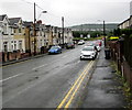
1
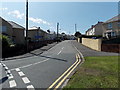
North Avenue, Tredegar
Viewed from the Sycamore Avenue end.
Image: © Jaggery
Taken: 22 Aug 2013
0.02 miles
2
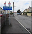
Signs at the eastern end of North Avenue, Tredegar
Two small signs are above a Restricted Access Ahead sign.
The sign on the right shows NO COLD CALLING ZONE. Its Welsh equivalent is on the left.
Image: © Jaggery
Taken: 7 Aug 2019
0.04 miles
3
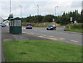
Ashvale bus stop and shelter, Tredegar
Near the corner of North Avenue and Sycamore Avenue (behind the camera).
The trees in the background are alongside the A4048.
Image: © Jaggery
Taken: 7 Aug 2019
0.04 miles
4
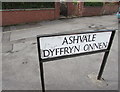
Bilingual Ashvale name sign, Tredegar
Ashvale is Dyffryn Onnen in Welsh.
Image: © Jaggery
Taken: 7 Aug 2019
0.05 miles
5
East along Ashvale, Tredegar
Looking east along the road named Ashvale towards the A4048 in the Ashvale area of Tredegar.
The road here is about 335 metres (1,100 ft) above mean sea level.
Image: © Jaggery
Taken: 19 Jul 2019
0.05 miles
6
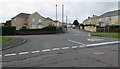
Junction of four roads in Tredegar
Viewed from the northwest end of Charles Street. Ashvale is in the lower right corner.
Sycamore Avenue is ahead on the left, North Avenue ahead on the right.
Image: © Jaggery
Taken: 7 Aug 2019
0.05 miles
7
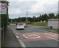
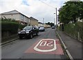
From 20 to 30, Sycamore Avenue, Tredegar
The 20mph speed limit in force near a school increases to 30mph.
Image: © Jaggery
Taken: 7 Aug 2019
0.05 miles
8
Wales & West Utilities gas installation on a Tredegar corner
On the corner of Charles Street and Sycamore Avenue.
The gas installation identifier is CHARLES ST TREDEGAR DG.
Image: © Jaggery
Taken: 7 Aug 2019
0.05 miles
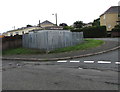
9
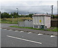
Sycamore Avenue electricity substation, Tredegar
The large grey cabinet is a Western Power Distribution electricity substation.
Its identifier is SYCAMORE AVE DUKESTOWN S/S 551489.
Image: © Jaggery
Taken: 7 Aug 2019
0.05 miles
10
Along Maple Avenue, Tredegar
From Sycamore Avenue along Maple Avenue towards Fair View.
The 20mph speed near a school increases to 30mph.
Image: © Jaggery
Taken: 7 Aug 2019
0.06 miles