IMAGES TAKEN NEAR TO
Church Street, TREDEGAR, NP22 3DX
Introduction
This page details the photographs taken nearby to Church Street, NP22 3DX by members of the Geograph project.
The Geograph project started in 2005 with the aim of publishing, organising and preserving representative images for every square kilometre of Great Britain, Ireland and the Isle of Man.

There are currently over 7.5m images from over14,400 individuals and you can help contribute to the project by visiting https://www.geograph.org.uk
Image Map
Images are licensed for reuse under creativecommons.org/licenses/by-sa/2.0
Notes
- Clicking on the map will re-center to the selected point.
- The higher the marker number, the further away the image location is from the centre of the postcode.
Image Listing (150 Images Found)
Images are licensed for reuse under creativecommons.org/licenses/by-sa/2.0
Image
Details
Distance
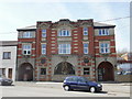
1
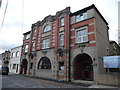
The Central Surgery of the Tredegar Medical Aid & Sick Relief Fund
Used as a model by Nye Bevan who stated: "The collective principle asserts that no society can legitimately call itself civilised if a sick person is denied medical aid because of lack of means." This building is dated 1911.
Image: © Jeremy Bolwell
Taken: 13 Oct 2012
0.00 miles
2
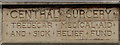
Central Surgery inscription, Tredegar
On this https://www.geograph.org.uk/photo/1821167 Church Street building.
Image: © Jaggery
Taken: 7 Aug 2019
0.00 miles
3
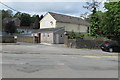
Tredegar Constitutional Club, Tredegar
Set back from the west side of Church Street.
Image: © Jaggery
Taken: 1 Jun 2017
0.02 miles
4
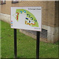
St George's Court map, Tredegar
Facing Church Street, the Tai Calon Community Housing map shows the location of the 130 flats in St George's Court. https://www.geograph.org.uk/photo/6231852 https://www.geograph.org.uk/photo/6231855
Image: © Jaggery
Taken: 7 Aug 2019
0.02 miles
5
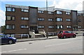
St George's Court, Tredegar
Tai Calon Community Housing flats on the east side of Church Street.
Image: © Jaggery
Taken: 1 Jun 2017
0.02 miles
6
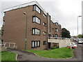
West side of St George's Court, Tredegar
Church Street side of an extensive area of flats near St George's Church.
Image: © Jaggery
Taken: 7 Aug 2019
0.03 miles
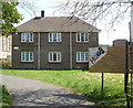
7
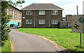
St George's Vicarage, Tredegar
Located on the south side of St George's church, on the right here. http://www.geograph.org.uk/photo/5414034
Image: © Jaggery
Taken: 1 Jun 2017
0.04 miles
8
Former Central Surgery, Tredegar
Located on Church Street, the Grade II listed building is now Cwm Seren Care Home, accommodating up to 29 residents.
The building was erected as the Central Surgery in 1911 by the Tredegar Medical Aid and Sick Relief Fund. The surgery provided consulting and treatment rooms, a pharmacy and a waiting room.
The Fund was used by Tredegar-born Aneurin Bevan as the model for the National Health Service.
Image: © Jaggery
Taken: 21 Apr 2010
0.04 miles
9

Church Street, Tredegar
Houses on the west side of the street.
Image: © Jaggery
Taken: 21 Apr 2010
0.04 miles
10
St George's Vicarage, Tredegar
Located on Church Street, on the south side of the church.http://www.geograph.org.uk/photo/1821183
Image: © Jaggery
Taken: 21 Apr 2010
0.04 miles