IMAGES TAKEN NEAR TO
Tafarnaubach, TREDEGAR, NP22 3AP
Introduction
This page details the photographs taken nearby to NP22 3AP by members of the Geograph project.
The Geograph project started in 2005 with the aim of publishing, organising and preserving representative images for every square kilometre of Great Britain, Ireland and the Isle of Man.

There are currently over 7.5m images from over14,400 individuals and you can help contribute to the project by visiting https://www.geograph.org.uk
Image Map
Images are licensed for reuse under creativecommons.org/licenses/by-sa/2.0
Notes
- Clicking on the map will re-center to the selected point.
- The higher the marker number, the further away the image location is from the centre of the postcode.
Image Listing (78 Images Found)
Images are licensed for reuse under creativecommons.org/licenses/by-sa/2.0
Image
Details
Distance
1
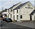
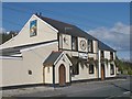
Nags Head, Tafarnaubach
Merthyr Road pub near the A465 Heads of the Valleys Road near Tredegar.
The road here is 375 metres (1,230 ft) above mean sea level.
Image: © Jaggery
Taken: 15 Apr 2019
0.01 miles

3
Nags Head, Merthyr Road, Tafarnaubach
Pub near the A465 Heads of the Valleys Road near Tredegar.
The road here is 375 metres (1,230 ft) above mean sea level.
Image: © Jaggery
Taken: 15 Apr 2019
0.01 miles
4
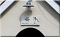
The Nags Head name sign, Tafarnaubach
Small sign over the doorway here. https://www.geograph.org.uk/photo/6120426
Image: © Jaggery
Taken: 15 Apr 2019
0.01 miles
5
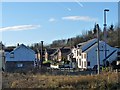
Tafarnaubach
Viewed from a bridge over the A465 Heads of the Valleys road.
The Nags Head Inn is on the right http://www.geograph.org.uk/photo/589384 .
Image: © Robin Drayton
Taken: 5 Dec 2012
0.01 miles
7
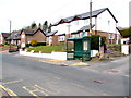
Merthyr Road bus stop and shelter near the Nags Head, Tafarnaubach
In April 2019 the shelter is alongside a stop on Harris Coaches bus route 20 to Tredegar.
The stop on the camera side is for buses to Rhymney and Rhymney railway station.
The Nags Head pub https://www.geograph.org.uk/photo/6120426 is out of shot on the right.
Image: © Jaggery
Taken: 15 Apr 2019
0.01 miles
8
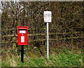
Queen Elizabeth II postbox, Merthyr Road, Tafarnaubach
Located near the Nags Head pub https://www.geograph.org.uk/photo/6120413 out of shot on the left. In April 2019 the notice shows
ANY PERSON FOUND LITTERING OR NOT CLEANING UP AFTER THEIR DOG WILL BE FINED £125.
Image: © Jaggery
Taken: 15 Apr 2019
0.02 miles
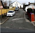
9
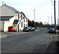
East along Merthyr Road, Tafarnaubach
The Nags Head pub https://www.geograph.org.uk/photo/6120426 is on the left.
Image: © Jaggery
Taken: 15 Apr 2019
0.02 miles
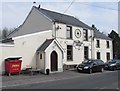
10
No Entry signs, Tafarnaubach
Facing Merthyr Road. Siloam Baptist Chapel https://www.geograph.org.uk/photo/6120504 is in the background.
Image: © Jaggery
Taken: 15 Apr 2019
0.03 miles