IMAGES TAKEN NEAR TO
Tafarnaubach Industrial Estate, TREDEGAR, NP22 3AA
Introduction
This page details the photographs taken nearby to Tafarnaubach Industrial Estate, NP22 3AA by members of the Geograph project.
The Geograph project started in 2005 with the aim of publishing, organising and preserving representative images for every square kilometre of Great Britain, Ireland and the Isle of Man.

There are currently over 7.5m images from over14,400 individuals and you can help contribute to the project by visiting https://www.geograph.org.uk
Image Map
Images are licensed for reuse under creativecommons.org/licenses/by-sa/2.0
Notes
- Clicking on the map will re-center to the selected point.
- The higher the marker number, the further away the image location is from the centre of the postcode.
Image Listing (38 Images Found)
Images are licensed for reuse under creativecommons.org/licenses/by-sa/2.0
Image
Details
Distance
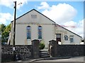
1
Welfare Hall, Merthyr Road, Tafarnaubach
Coflein records that Tafarnaubach & Princetown Miners' Welfare Hall opened in 1937 as a branch of the Tredegar Workmen's Institute. Funded through a grant from the Miners' Welfare Fund, the hall provided facilities typical of workmen's institutes of that period.
Image: © Jaggery
Taken: 15 Apr 2019
0.09 miles
2

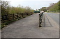
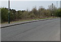
Fenced-off part of Merthyr Road, Tafarnaubach
In April 2019 temporary metal fencing extends for about 100 metres along the north side of Merthyr Road.
Image: © Jaggery
Taken: 15 Apr 2019
0.09 miles
3
Private car park, Merthyr Road, Tafarnaubach
The notice on the left shows CLAIRTEX GWENT LTD. PRIVATE CAR PARK. ALL VEHICLES LEFT AT YOUR OWN RISK. CCTV IN OPERATION.
Image: © Jaggery
Taken: 15 Apr 2019
0.10 miles
4
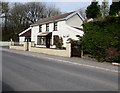
Former Travellers Rest pub, Merthyr Road, Tafarnaubach
The house named Travellers Rest used to be a Rhymney Brewery pub with the same name.
Image: © Jaggery
Taken: 15 Apr 2019
0.11 miles
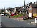
5
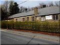
Brecon Terrace, Tafarnaubach
Houses on the north side of Merthyr Road which here is 375 metres (1,230 feet) above mean sea level.
Image: © Jaggery
Taken: 15 Apr 2019
0.12 miles
6
Speed camera warning sign in Tafarnaubach
On a Merthyr Road lamppost.
Image: © Jaggery
Taken: 15 Apr 2019
0.12 miles
8
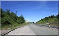
Welcome to Blaenau Gwent
On the Heads of the Valleys Road (A465).
Image: © Jonathan Thacker
Taken: 22 Jun 2018
0.14 miles
9
Siloam Baptist Chapel, Tafarnaubach
The plaque says SILOAM / CAPEL BEDYDDWYR / ADEILADWYD 1844 / AILADEILADWYD 1877 (Siloam Baptist Chapel, Built 1844, Rebuilt 1877).
Siloam is a Biblical place name.
Image: © Robin Drayton
Taken: 26 Sep 2007
0.15 miles
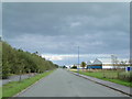
10
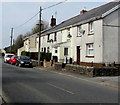
Merthyr Road houses, Tafarnaubach
On the north side of Merthyr Road which here is 375 metres (1,230 ft) above mean sea level.
Image: © Jaggery
Taken: 15 Apr 2019
0.15 miles