IMAGES TAKEN NEAR TO
Bettws Lane, NEWPORT, NP20 7YB
Introduction
This page details the photographs taken nearby to Bettws Lane, NP20 7YB by members of the Geograph project.
The Geograph project started in 2005 with the aim of publishing, organising and preserving representative images for every square kilometre of Great Britain, Ireland and the Isle of Man.

There are currently over 7.5m images from over14,400 individuals and you can help contribute to the project by visiting https://www.geograph.org.uk
Image Map
Images are licensed for reuse under creativecommons.org/licenses/by-sa/2.0
Notes
- Clicking on the map will re-center to the selected point.
- The higher the marker number, the further away the image location is from the centre of the postcode.
Image Listing (266 Images Found)
Images are licensed for reuse under creativecommons.org/licenses/by-sa/2.0
Image
Details
Distance
1
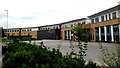
North side of Newport High School
Viewed from Bettws Lane in the Bettws area of Newport.
Image: © Jaggery
Taken: 22 Aug 2018
0.01 miles
2
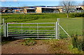
Newport High School from a field gate
The SE side of Newport High School, Bettws Lane, viewed past a field gate near Woodstock Pool.
Image: © Jaggery
Taken: 4 Feb 2015
0.02 miles
3
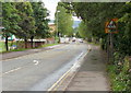
Bettws Lane, Newport
Looking along Bettws Lane towards Monnow Way. Apart from a few narrow country roads, Bettws Lane is the only access road to and from Bettws, one of the largest modern housing estates in Europe - its population at the 2001 census was 8,200. It is therefore no surprise that Bettws Lane gets very congested at peak travel times.
Elsewhere in Newport, Forge Lane was renamed Forge Road some time ago. Perhaps it's time that Bettws Lane became Bettws Road, or perhaps Bettws Avenue (there are many trees along its length)
Image: © Jaggery
Taken: 24 Aug 2009
0.02 miles
4
Bilingual welcome to Newport High School, Bettws, Newport
On the south side of Bettws Lane. Croeso is Welsh for Welcome.
Image: © Jaggery
Taken: 5 Jan 2016
0.04 miles
5
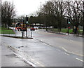
Bettws Lane pelican crossing, Newport
Near Newport High School. Chambers Dictionary states that the term pelican crossing is adapted from "pedestrian light controlled crossing". A drain cleaning lorry http://www.geograph.org.uk/photo/4790546 is at work in the background.
Image: © Jaggery
Taken: 5 Jan 2016
0.06 miles
6
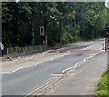
Pelican crossing, Bettws Lane, Newport
Chambers Dictionary states that pelican in this context
is adapted from "pedestrian light controlled crossing".
Image: © Jaggery
Taken: 20 Jul 2024
0.06 miles
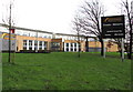
7
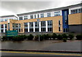
Welcome to Newport High School, Bettws Lane, Newport
The green Welcome sign faces the school access road on the south side of Bettws Lane. The original Newport High School was a grammar school located near the centre of Newport, founded in 1896. In 2016, Newport High School is a large comprehensive school at the eastern edge of the Bettws housing estate in the northwest of the city.
The school has c1,100 pupils and c85 staff. This 21st century school was built in front of the old Bettws Comprehensive School, dating from 1970. The old school site was sold to Barratt Homes for demolition and house building.
Image: © Jaggery
Taken: 5 Jan 2016
0.06 miles
8

Silver car in transit, Bettws Lane, Newport
Passing Newport High School on the route towards the A4051 Malpas Road.
Image: © Jaggery
Taken: 22 Aug 2018
0.07 miles
9
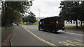
UPS Worldwide Services vehicle, Bettws Lane, Newport
UPS (United Parcel Service, Inc.) is an American multinational package delivery company.
Its headquarters are in Sandy Springs, Georgia, USA.
Image: © Jaggery
Taken: 22 Aug 2018
0.07 miles
10
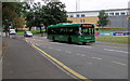
Bettws Circular bus, Bettws Lane, Newport
The green Newport Bus single-decker is on bus route 15 Bettws Circular in August 2018.
Image: © Jaggery
Taken: 22 Aug 2018
0.07 miles