IMAGES TAKEN NEAR TO
Medway Close, NEWPORT, NP20 7XB
Introduction
This page details the photographs taken nearby to Medway Close, NP20 7XB by members of the Geograph project.
The Geograph project started in 2005 with the aim of publishing, organising and preserving representative images for every square kilometre of Great Britain, Ireland and the Isle of Man.

There are currently over 7.5m images from over14,400 individuals and you can help contribute to the project by visiting https://www.geograph.org.uk
Image Map
Images are licensed for reuse under creativecommons.org/licenses/by-sa/2.0
Notes
- Clicking on the map will re-center to the selected point.
- The higher the marker number, the further away the image location is from the centre of the postcode.
Image Listing (98 Images Found)
Images are licensed for reuse under creativecommons.org/licenses/by-sa/2.0
Image
Details
Distance
1
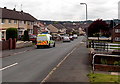
Police van in Medway Road, Bettws, Newport
Viewed from the corner of Leach Road.
Image: © Jaggery
Taken: 29 May 2014
0.03 miles
2
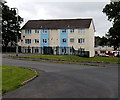
Medway Court flats, Bettws, Newport
3-storey block of flats viewed from the northern end of Weare Close.
Image: © Jaggery
Taken: 29 May 2014
0.05 miles
3
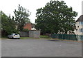
Weare Close electricity substation, Bettws, Newport
Located in the NW corner of Weare Close. The identifier on the Western Power Distribution (WPD) electricity substation is WEARE CLOSE S/S No 53-2207. A red notice on the wall informs WPD staff that remote control actuators are fitted to 11kV switchgear - contact control before entry.
Image: © Jaggery
Taken: 29 May 2014
0.06 miles
4
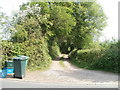
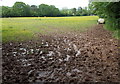
Newport : track from Bettws to Ty'n-y-pwll Farm
Viewed across Leach Road, which is at the northern edge of the Bettws housing estate. Northwards for about three kilometres, the land is used for farming (chiefly grazing land). The farmland ends at the southern edge of residential Cwmbran.
Image: © Jaggery
Taken: 4 May 2011
0.06 miles
5

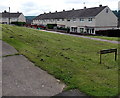
Torridge Road houses, Bettws, Newport
Looking NNE towards Leach Road.
Image: © Jaggery
Taken: 29 May 2014
0.06 miles
6
Rother Close, Bettws, Newport
Access to this side of Rother Close is via paths from Leach Road.
Vehicular access is from Trent Road on the far side.
Image: © Jaggery
Taken: 29 May 2014
0.07 miles
7
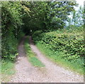
Track to Ty'n-y-pwll north of Bettws, Newport
On the north side of Leach Road, near the Torridge Road junction.
Image: © Jaggery
Taken: 29 May 2014
0.07 miles
8
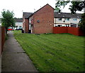
Path to Torridge Road, Bettws, Newport
From Weare Close.
Image: © Jaggery
Taken: 29 May 2014
0.08 miles
9
Muddy access to a field from Leach Road, Bettws, Newport
Viewed in late May 2014.
Image: © Jaggery
Taken: 29 May 2014
0.08 miles
10
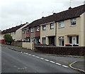
Weare Close houses, Bettws, Newport
Looking NE from the Medway Road end.
Image: © Jaggery
Taken: 29 May 2014
0.08 miles