IMAGES TAKEN NEAR TO
Allen Close, NEWPORT, NP20 7RZ
Introduction
This page details the photographs taken nearby to Allen Close, NP20 7RZ by members of the Geograph project.
The Geograph project started in 2005 with the aim of publishing, organising and preserving representative images for every square kilometre of Great Britain, Ireland and the Isle of Man.

There are currently over 7.5m images from over14,400 individuals and you can help contribute to the project by visiting https://www.geograph.org.uk
Image Map
Images are licensed for reuse under creativecommons.org/licenses/by-sa/2.0
Notes
- Clicking on the map will re-center to the selected point.
- The higher the marker number, the further away the image location is from the centre of the postcode.
Image Listing (73 Images Found)
Images are licensed for reuse under creativecommons.org/licenses/by-sa/2.0
Image
Details
Distance
1
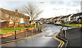
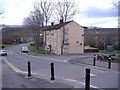
Traffic calming, Monnow Way,Bettws
Monnow Way briefly narrows to the width of one vehicle, with a hump in the
roadway to discourage speeding. The metal posts on both sides of the road prevent vehicles using the pavement at this point. Located between the junctions for Roding Close and Allen Close.
Image: © Jaggery
Taken: 7 Nov 2009
0.02 miles
2
Tyne Close, Bettws, Newport
Viewed from Monnow Way.
Image: © Jaggery
Taken: 7 Nov 2009
0.02 miles
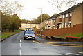
3
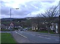
Monnow Way, Bettws
With Twmbarlwm (419 metres), in the distance.
Image: © Roger Cornfoot
Taken: 1 Mar 2007
0.04 miles
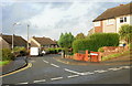
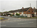
4
Ogmore Crescent, Bettws, Newport
Looking along Ogmore Crescent from the junction with Bettws Hill towards the Monnow Way roundabout.
Image: © Jaggery
Taken: 7 Nov 2009
0.04 miles
6
Roding Close, Bettws, Newport
Viewed from Monnow Way.
Image: © Jaggery
Taken: 7 Nov 2009
0.06 miles
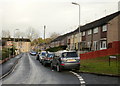
7
Darent Road, Bettws, Newport
Houses on the south side of Darent Road, viewed from Monnow Way.
Most streets in Bettws are named after UK rivers.
Image: © Jaggery
Taken: 19 May 2010
0.07 miles
8
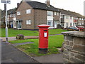
Pillarbox anachronism, Chelmer Walk, Bettws, Newport
The King George V pillarbox on the corner of Chelmer Walk and Monnow Way, Bettws, dates from some time between 1910 and 1936, decades before the construction of the Bettws housing estate (1960s). In the first half of the 20th century, this was a rural, sparsely populated area which would not have warranted a pillarbox.
Image: © Jaggery
Taken: 7 Nov 2009
0.07 miles
9
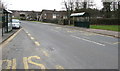
Monnow Way bus stops and shelters, Bettws, Newport
Located near Nidd Close. http://www.geograph.org.uk/photo/4850576
Image: © Jaggery
Taken: 29 Feb 2016
0.07 miles
10
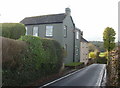
Two houses on Bettws Hill
On the south side of Bettws Hill, close to its end at Ogmore Crescent, are Brooklands and Ty Maen.
Image: © Jaggery
Taken: 7 Nov 2009
0.08 miles