IMAGES TAKEN NEAR TO
Meon Close, NEWPORT, NP20 7DU
Introduction
This page details the photographs taken nearby to Meon Close, NP20 7DU by members of the Geograph project.
The Geograph project started in 2005 with the aim of publishing, organising and preserving representative images for every square kilometre of Great Britain, Ireland and the Isle of Man.

There are currently over 7.5m images from over14,400 individuals and you can help contribute to the project by visiting https://www.geograph.org.uk
Image Map
Images are licensed for reuse under creativecommons.org/licenses/by-sa/2.0
Notes
- Clicking on the map will re-center to the selected point.
- The higher the marker number, the further away the image location is from the centre of the postcode.
Image Listing (182 Images Found)
Images are licensed for reuse under creativecommons.org/licenses/by-sa/2.0
Image
Details
Distance
1
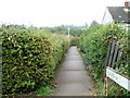
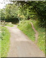
Parret Walk, Bettws, Newport
Parret Walk heads away from Parret Road past the SE edge of Millbrook Primary School, towards Meon Close and Parret Close.
Image: © Jaggery
Taken: 5 Sep 2010
0.06 miles
2
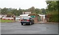
Entrance to St David Lewis school, Bettws, Newport
This entrance to Saint David Lewis Roman Catholic Primary School is from Meon Close.
Saint David Lewis RC church is nearby. http://www.geograph.org.uk/photo/1567951
Image: © Jaggery
Taken: 5 Sep 2010
0.06 miles
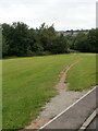
3
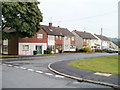
Meon Close, Bettws, Newport
Houses on the east side of the close, viewed from Parret Close.
Image: © Jaggery
Taken: 5 Sep 2010
0.06 miles
4
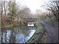
Wooden canal bridge, Malpas, Newport
The wooden bridge is a recent addition, in contrast to the stone bridges http://www.geograph.org.uk/photo/1904356 which were built two centuries ago. It gives access between the footpath along the former Monmouthshire & Brecon Canal, and Darwin Drive, Malpas.
UPDATE November 2011. A new bridge http://www.geograph.org.uk/photo/2700442 has replaced the wooden one.
Image: © Jaggery
Taken: 6 Feb 2010
0.07 miles
5
Side track heads away from National Cycle Route 49, Malpas, Newport
A narrow track heads away from the disused Monmouthshire & Brecon Canal. The towpath is now part of National Cycle Network route 49. On the left is a wooden bridge http://www.geograph.org.uk/photo/2306557 across the canal.
Image: © Jaggery
Taken: 30 Jul 2010
0.07 miles
6
Track from Faraday Close, Newport to disused canal
A track descends towards a wooden bridge http://www.geograph.org.uk/photo/2306557 giving access to the disused Monmouthshire & Brecon canal towpath, now part of National Cycle Network route 49.
Image: © Jaggery
Taken: 30 Jul 2010
0.07 miles
7
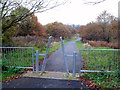
Path south to Bettws from canal, Malpas, Newport
The path is adjacent to this http://www.geograph.org.uk/photo/2700442 bridge over the disused Monmouthshire & Brecon canal. Ahead is the Bettws area of Newport
Image: © Jaggery
Taken: 19 Nov 2011
0.07 miles
8
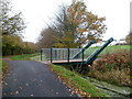
New canal bridge, Malpas, Newport
The bridge seen here replaced a small wooden bridge. http://www.geograph.org.uk/photo/2306557
It looks as though the replacement occurred so that this bridge can be raised to allow recreational navigation along a section of formerly derelict waterway on the Monmouthshire & Brecon canal. The far side of the bridge leads to a track to Faraday Close and Darwin Drive.
Image: © Jaggery
Taken: 19 Nov 2011
0.07 miles
9
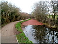
Reddish surface colour on canal water, Malpas
Is the reddish colour of the algae viewed from this bridge http://www.geograph.org.uk/photo/2700442 in late March 2012 a seasonal variation? A summer view http://www.geograph.org.uk/photo/2001931 of a nearby section of the disused Monmouthshire & Brecon canal shows the usual green.
Image: © Jaggery
Taken: 21 Mar 2012
0.07 miles
10
Parret Close, Bettws, Newport
Viewed across Monnow Way. Parret Close leads to Parret Walk, Meon Close and Tees Close.
Image: © Jaggery
Taken: 20 Aug 2018
0.08 miles