1
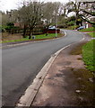
Towards a bend in The Firs, Malpas, Newport
The Firs is a cul-de-sac on the south side of Pillmawr Road.
A grey Royal Mail drop box https://www.geograph.org.uk/photo/5723551 is near a tree on the left.
Image: © Jaggery
Taken: 31 Mar 2018
0.02 miles
2
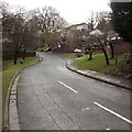
South along The Firs, Newport
Part of a 110 metre long cul-de-sac on the south side of Pillmawr Road.
Image: © Jaggery
Taken: 15 Dec 2014
0.03 miles
3
Grove Park play area, Malpas, Newport
A small enclosed area near the Grove Park entrance, containing a slide, swings, rocking horse and climbing frame. Before the construction of the A4042 in the 1990s, which went through the southeast side of the park, there was a larger play area at the other end of the park.
Image: © Jaggery
Taken: 7 Oct 2009
0.03 miles
4
Path alongside Grove Park MURA, Newport
MURA is a Multi Use Recreational Area. This is a large steel enclosure that can be used for a variety of sporting activities such as football, basketball, skating, tennis and netball.
Grove Park opened in April 1952 as Newport's 25th public open space. About a third of the park was lost when the Malpas Road Relief Road (now the A4042) was built in the 1990s through what were the east and southeast parts of the park.
Image: © Jaggery
Taken: 30 Sep 2009
0.03 miles
5
Dead Gladiator, Malpas, Newport
Viewed from the path leading from Grove Park.
The Gladiator pub closed in 2009 and is now boarded up and lifeless.
Image: © Jaggery
Taken: 30 Sep 2009
0.03 miles
6
Grove Park lodge, Malpas, Newport
Located at the northern edge of Grove Park.
Image: © Jaggery
Taken: 30 Sep 2009
0.03 miles
7
Old Railway after the Snow
The old railway near Pilton Vale seems well-trodden after a recent snowfall.
Image: © David Roberts
Taken: 3 Feb 2009
0.03 miles
8
The Firs, Malpas, Newport
The Firs is a cul-de-sac , seen here from Pillmawr Road.
Image: © Jaggery
Taken: 15 Aug 2009
0.03 miles
9
Path along former railway trackbed, Malpas
The Pillmawr Road side of a path http://www.geograph.org.uk/photo/1332750 above Grove Park, along the trackbed of a dismantled railway.
Image: © Jaggery
Taken: 1 Jan 2010
0.03 miles
10
Looking north along The Firs, Newport
The view from near the woodside end http://www.geograph.org.uk/photo/1978843 of a cul-de-sac, looking in the direction of Pillmawr Road.
Image: © Jaggery
Taken: 7 Oct 2009
0.03 miles


