IMAGES TAKEN NEAR TO
Alanbrooke Avenue, NEWPORT, NP20 6QJ
Introduction
This page details the photographs taken nearby to Alanbrooke Avenue, NP20 6QJ by members of the Geograph project.
The Geograph project started in 2005 with the aim of publishing, organising and preserving representative images for every square kilometre of Great Britain, Ireland and the Isle of Man.

There are currently over 7.5m images from over14,400 individuals and you can help contribute to the project by visiting https://www.geograph.org.uk
Image Map
Images are licensed for reuse under creativecommons.org/licenses/by-sa/2.0
Notes
- Clicking on the map will re-center to the selected point.
- The higher the marker number, the further away the image location is from the centre of the postcode.
Image Listing (345 Images Found)
Images are licensed for reuse under creativecommons.org/licenses/by-sa/2.0
Image
Details
Distance
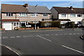
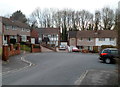
1
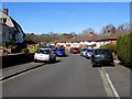
Cars parked on Alanbrooke Avenue pavements, Malpas, Newport
Walkers have to use to the roadway to pass cars parked on pavements. All the houses have garages,
so perhaps these are visitors' cars, or maybe the garages contain freezers, washing machines etc.
Image: © Jaggery
Taken: 7 Mar 2015
0.01 miles
2
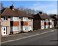
Alanbrooke Avenue houses, Malpas, Newport
Semi-detached houses set slightly below road level.
Image: © Jaggery
Taken: 7 Mar 2015
0.02 miles
3
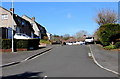
SE end of Alanbrooke Avenue, Malpas, Newport
Alanbrooke Avenue climbs away from Horrocks Close.
Image: © Jaggery
Taken: 7 Mar 2015
0.02 miles
4
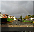
Faint rainbow over Malpas, Newport
Looking north from Almond Drive along Wavell Drive at 9am on November 1st 2020.
Image: © Jaggery
Taken: 1 Nov 2020
0.02 miles
5
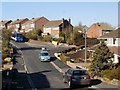
Junction of Alanbrooke Avenue and Wavell Drive, Malpas, Newport
Viewed from Montgomery Road. Left for Alanbrooke Avenue, right for Wavell Drive.
The roads in this area are named after Second World War field marshals and generals.
Image: © Jaggery
Taken: 7 Mar 2015
0.04 miles
6
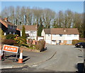
Hilly Malpas, Newport
There is not much flat terrain in this part of Malpas. The view is from Wavell Drive looking beyond the right turning to Horrocks Close, to the start of Alanbrooke Avenue, which would have been better named Alanbrooke Crescent, for it bends in a horseshoe shape to the north of Horrocks Close, which it rejoins at its end.
Image: © Jaggery
Taken: 8 Mar 2010
0.06 miles
7
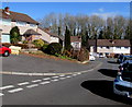
Corner of Horrocks Close and Alanbrooke Avenue, Malpas, Newport
Alanbrooke Avenue is on the left. The roads are named after Second World War field marshals and generals.
Lieutenant General Sir Brian Gwynne Horrocks KCB, KBE, DSO, MC (1895–1985) was the commander of XXX Corps in Operation Market Garden and other operations during the Second World War.
Field Marshal Alan Francis Brooke, 1st Viscount Alanbrooke KG, GCB, OM, GCVO, DSO & Bar (1883–1963) was the Chief of the Imperial General Staff during the Second World War. He was promoted to field marshal in 1944.
Image: © Jaggery
Taken: 7 Mar 2015
0.07 miles
8
Far end of Horrocks Close, Malpas, Newport
Viewed from the corner of Wavell Drive.
Image: © Jaggery
Taken: 8 Mar 2010
0.07 miles
9
Turning circle at the far end of Horrocks Close, Malpas, Newport
Horrocks Close connects with Wavell Drive.
Image: © Jaggery
Taken: 13 Feb 2012
0.07 miles
10
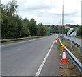
Link road from A4051 to A4042
The view from the edge of Woodlands Roundabout and the A4051 (Malpas Road and Cwmbran Drive) along one carriageway of the 400 metre long connecting road to Croes-y-Mwyalch Roundabout and the A4042 (Llantarnam bypass to the north and Malpas bypass to the south).
Image: © Jaggery
Taken: 7 Aug 2010
0.08 miles