IMAGES TAKEN NEAR TO
Westfield Rise, NEWPORT, NP20 6GA
Introduction
This page details the photographs taken nearby to Westfield Rise, NP20 6GA by members of the Geograph project.
The Geograph project started in 2005 with the aim of publishing, organising and preserving representative images for every square kilometre of Great Britain, Ireland and the Isle of Man.

There are currently over 7.5m images from over14,400 individuals and you can help contribute to the project by visiting https://www.geograph.org.uk
Image Map
Images are licensed for reuse under creativecommons.org/licenses/by-sa/2.0
Notes
- Clicking on the map will re-center to the selected point.
- The higher the marker number, the further away the image location is from the centre of the postcode.
Image Listing (2180 Images Found)
Images are licensed for reuse under creativecommons.org/licenses/by-sa/2.0
Image
Details
Distance
1
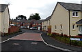
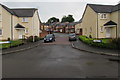
Westfield Rise, Malpas, Newport
Viewed from Westfield Way. Westfield Rise is an early 2010s Bellway development of detached houses on the site formerly occupied by Westfield School and Westfield Clinic. http://www.geograph.org.uk/photo/1643936
Image: © Jaggery
Taken: 18 Jun 2014
0.01 miles
2
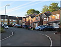
Westfield Rise, Newport
Westfield Rise is a cul-de-sac on the south side of Westfield Way in the Malpas area of Newport.
Westfield Rise and its houses were built in the early part of the second decade of the 21st century.
Image: © Jaggery
Taken: 14 May 2019
0.01 miles
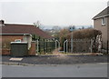
3
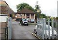
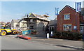
Grange Clinic, Malpas, Newport
Located at the end of Westfield Avenue.
In the top left corner is a part of a shop set back from Malpas Road, several metres above the level of Westfield Avenue.
Image: © Jaggery
Taken: 2 Sep 2009
0.02 miles
4
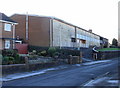
Site of former Westfield School and Westfield Clinic, Malpas
The derelict and boarded up building on Westfield Way was formerly the location of Westfield Clinic and Westfield School. The building became unoccupied when Westfield Upper and Lower schools merged to form Maes Ebbw School, Maesglas Road, Newport.
UPDATE. The buildings have been demolished and replaced by the Westfield Rise housing development. http://www.geograph.org.uk/photo/4032585
Image: © Jaggery
Taken: 2 Jan 2010
0.02 miles
5
Path from Westfield Way to recreation field, Malpas, Newport
The other end of the short path is at the edge of a recreation area bordering Russell Drive and Darwin Drive.
A Newport City Council sign declares "No Fly Tipping" and enforces the warning with a £2,500 fine for anyone convicted of fly tipping here.
In March 2010, Fly Tipping Action Wales reported that there are 55,000 incidents of fly tipping in Wales every year. The annual clean-up costs taxpayers in Wales £3 million. A third of these incidents involve construction and demolition waste.
Image: © Jaggery
Taken: 18 Mar 2010
0.02 miles
6
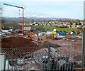
Building site, Westfield Way, Newport
Viewed from higher ground in the parking area of Malpas Road shops. In early February 2012, construction work is under way on the site of the former Westfield school and clinic. http://www.geograph.org.uk/photo/1643936
The planning permission document for the site refers to "residential development of 24 units".
Image: © Jaggery
Taken: 5 Feb 2012
0.02 miles
7
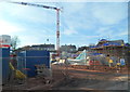
Early stage in the construction of Westfield Rise, Malpas, Newport
This view taken on Westfield Way in early February 2012 shows that work has begun on the construction of 24 new houses. This is a Bellway development, named Westfield Rise.
The site was previously occupied by Westfield School and Westfield Clinic. http://www.geograph.org.uk/photo/1643936
Image: © Jaggery
Taken: 9 Feb 2012
0.02 miles
8
Early August 2012 view of Westfield Rise construction site, Malpas, Newport
Viewed from the parking area adjacent to Malpas Road shops.
The site was previously occupied by Westfield School and Westfield Clinic. http://www.geograph.org.uk/photo/1643936
Image: © Jaggery
Taken: 5 Aug 2012
0.02 miles
9
Westfield Rise, Malpas, Newport
Westfield Rise is a cul-de-sac on the south side of Westfield Way.
Westfield Rise and its houses were built in the early part of the second decade of the 21st century.
Image: © Jaggery
Taken: 27 May 2017
0.02 miles
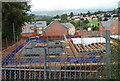
10
Building work in progress, Westfield Way, Malpas, Newport
An early March 2013 view of construction work at Bellway's Westfield Rise development.
Image: © Jaggery
Taken: 4 Mar 2013
0.02 miles