IMAGES TAKEN NEAR TO
Brynglas Drive, NEWPORT, NP20 5QS
Introduction
This page details the photographs taken nearby to Brynglas Drive, NP20 5QS by members of the Geograph project.
The Geograph project started in 2005 with the aim of publishing, organising and preserving representative images for every square kilometre of Great Britain, Ireland and the Isle of Man.

There are currently over 7.5m images from over14,400 individuals and you can help contribute to the project by visiting https://www.geograph.org.uk
Image Map
Images are licensed for reuse under creativecommons.org/licenses/by-sa/2.0
Notes
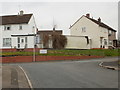
- Clicking on the map will re-center to the selected point.
- The higher the marker number, the further away the image location is from the centre of the postcode.
Image Listing (271 Images Found)
Images are licensed for reuse under creativecommons.org/licenses/by-sa/2.0
Image
Details
Distance
1
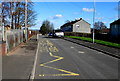
Zigzag yellow markings on Brynglas Drive, Newport
Marking a Keep Clear zone outside a primary school, Ysgol Gymraeg Bro Teyrnon.
Image: © Jaggery
Taken: 15 Feb 2016
0.01 miles
2
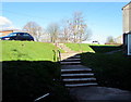
Steps up to Brynglas Drive, Newport
From a path alongside houses, steps ascend to Brynglas Drive and the entrance gates http://www.geograph.org.uk/photo/4828190
to the Welsh language school Ysgol Gymraeg Bro Teyrnon.
Image: © Jaggery
Taken: 15 Feb 2016
0.02 miles
3
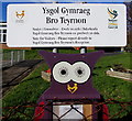
Ysgol Gymraeg Bro Teyrnon nameboard, Brynglas, Newport
Welsh language primary school on the west side of Brynglas Drive.
Brynglas Primary School was formerly on this site.
Image: © Jaggery
Taken: 15 Feb 2016
0.02 miles
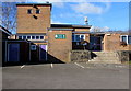
4
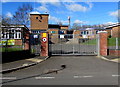
Locked school entrance gates, Brynglas Drive, Newport
In common with other schools in the city, the Welsh language school
Ysgol Gymraeg Bro Teyrnon is closed during half-term week in mid February 2016.
Image: © Jaggery
Taken: 15 Feb 2016
0.02 miles
5
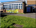
Welsh banner on a school wall, Brynglas, Newport
On a wall of Ysgol Gymraeg Bro Teyrnon, a Welsh-language primary school.
Image: © Jaggery
Taken: 15 Feb 2016
0.03 miles
6
Steps up to Ysgol Gymraeg Bro Teyrnon, Brynglas, Newport
Entrance to the Welsh language primary school viewed from the Brynglas Drive school gates. www.geograph.org.uk/photo/4828190
Image: © Jaggery
Taken: 15 Feb 2016
0.03 miles
7
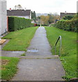
Footpath, Brynglas Drive
A footpath heads away from the northern part of Brynglas Drive to its southern part.
Image: © Jaggery
Taken: 25 Oct 2009
0.03 miles
8
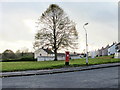
Tree and postbox, Brynglas
An area of grass at the top end of Brynglas Road is dominated by a tree about 20 metres behind the George VI postbox. Houses on Brynglas Drive are on the right.
Image: © Jaggery
Taken: 25 Oct 2009
0.03 miles
9
Junction of Brynglas Road and Brynglas Drive, Newport
The north end of Brynglas Road connects with Brynglas Drive, which forms an elongated loop around the highest part of Brynglas.
The sign suggests turning left for Brynglas Court and 1-81 and 2-56 Brynglas Drive
and turning right for Brynglas Close and 108-58 Brynglas Drive. There are no odd-numbered houses along this section of Brynglas Drive because it is occupied by Brynglas Primary School. http://www.geograph.org.uk/photo/1696390
Image: © Jaggery
Taken: 7 Feb 2010
0.03 miles
10

Brynglas bus terminus, Newport
The bus shelter beside the roundabout at the top of Brynglas Road is the terminus and turning point for the outbound Newport Bus route 13 from the bus station.
There are three variants on route 13 from the bus station:
13A via Redland Street, returns via Brynglas Road.
13C via Brynglas Road returns via Redland Street.
13E via Redland Street and Brynglas Drive, returns via Brynglas Road.
Image: © Jaggery
Taken: 7 Feb 2010
0.03 miles