IMAGES TAKEN NEAR TO
Blaen Y Pant Crescent, NEWPORT, NP20 5QE
Introduction
This page details the photographs taken nearby to Blaen Y Pant Crescent, NP20 5QE by members of the Geograph project.
The Geograph project started in 2005 with the aim of publishing, organising and preserving representative images for every square kilometre of Great Britain, Ireland and the Isle of Man.

There are currently over 7.5m images from over14,400 individuals and you can help contribute to the project by visiting https://www.geograph.org.uk
Image Map
Images are licensed for reuse under creativecommons.org/licenses/by-sa/2.0
Notes
- Clicking on the map will re-center to the selected point.
- The higher the marker number, the further away the image location is from the centre of the postcode.
Image Listing (478 Images Found)
Images are licensed for reuse under creativecommons.org/licenses/by-sa/2.0
Image
Details
Distance
1
New pavilion, Kimberley Park, Newport
A new pavilion and changing rooms building is being built in Kimberley Park for Albion Rovers football club. Their existing changing room is nearby. http://www.geograph.org.uk/photo/1722311
Image: © Jaggery
Taken: 22 Feb 2010
0.03 miles
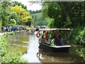
2
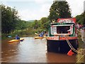
Narrowboat Maude-Again
'Maude-Again', moored by the towpath at Gwasted Lock, on the afternoon before the Welsh Waterways Festival 2010 at Kimberley Park.
Image: © David Roberts
Taken: 28 May 2010
0.03 miles
3
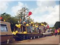
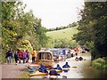
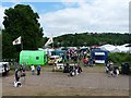
2010 Welsh Waterways Festival
Boat trips were a popular feature of the festival.
Image: © Robin Drayton
Taken: 31 May 2010
0.03 miles
5
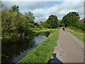
Canal bank at the edge of Kimberly Park, Newport
The disused Monmouthshire & Brecon Canal is behind the bank and wall.
Image: © Jaggery
Taken: 2 Jan 2015
0.03 miles
6
Monmouthshire and Brecon Canal in Crindau Park
Image: © David Smith
Taken: 26 Sep 2021
0.03 miles
8
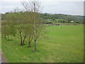
Kimberley Park, Newport
Viewed from the footbridge http://www.geograph.org.uk/photo/1499965 across Malpas Road. Kimberley Park (formerly known as Crindau Park) occupies land at the foot of Malpas hill bordered by Malpas Road, the M4 motorway, the former Monmouthshire & Brecon Canal, and Blaen-y-Pant Crescent. The park contains the home pitch http://www.geograph.org.uk/photo/1722176 and pavilion http://www.geograph.org.uk/photo/1722298 of Albion Rovers football club.
Image: © Jaggery
Taken: 2 May 2010
0.04 miles
9
Kimberley Park
Taken from the canal towpath.
This was the site for land based attractions associated with the 2010 Welsh Waterways Festival.
Image: © Robin Drayton
Taken: 31 May 2010
0.04 miles