IMAGES TAKEN NEAR TO
Walford Street, NEWPORT, NP20 5PH
Introduction
This page details the photographs taken nearby to Walford Street, NP20 5PH by members of the Geograph project.
The Geograph project started in 2005 with the aim of publishing, organising and preserving representative images for every square kilometre of Great Britain, Ireland and the Isle of Man.

There are currently over 7.5m images from over14,400 individuals and you can help contribute to the project by visiting https://www.geograph.org.uk
Image Map
Images are licensed for reuse under creativecommons.org/licenses/by-sa/2.0
Notes
- Clicking on the map will re-center to the selected point.
- The higher the marker number, the further away the image location is from the centre of the postcode.
Image Listing (1183 Images Found)
Images are licensed for reuse under creativecommons.org/licenses/by-sa/2.0
Image
Details
Distance
1

NW along Ross Lane, Crindau, Newport
From Goodrich Crescent.
Image: © Jaggery
Taken: 24 Feb 2023
0.01 miles
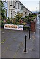
2
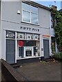
FIFTY FIVE, Malpas Road, Crindau, Newport
Names in view in August 2021 are Acoustics and Noise Limited on the left and Grate Choice Fires & Fireplaces on the right.
Image: © Jaggery
Taken: 9 Aug 2021
0.02 miles
3
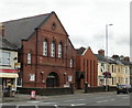
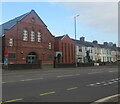
Malpas Road Evangelical Church, Newport
On the west side of Malpas Road, opposite the junction with Brynglas Road. Present name was adopted in 1976 - previously known as Malpas Road Presbyterian Church.
The date on the foundation stone is August 3rd 1896.
Image: © Jaggery
Taken: 6 Aug 2009
0.02 miles
4
Malpas Road Evangelical Church, Newport
On the west side of Malpas Road, viewed from Brynglas Road.
Previously known as Malpas Road Presbyterian Church, the current name was adopted in 1976.
The date on the foundation stone is August 3rd 1896.
Image: © Jaggery
Taken: 15 Nov 2015
0.02 miles
5
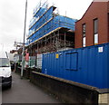
Scaffolding on Malpas Road Evangelical Church, Newport
Viewed in late October 2017. This http://www.geograph.org.uk/photo/4740325 November 2015 photo shows the church.
Image: © Jaggery
Taken: 26 Oct 2017
0.02 miles
6
Coronavirus update notice, Malpas Road Evangelical Church, Newport
The notice on this https://www.geograph.org.uk/photo/4740325 church on April 7th 2020
during the Coronavirus (COVID-19) pandemic states
"We have made the decision to cancel all church meetings and groups until further notice".
Image: © Jaggery
Taken: 7 Apr 2020
0.02 miles
7
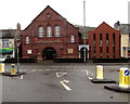
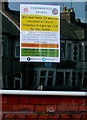
Vaccination centre in a church, Crindau, Newport
Viewed across the A4051 Malpas Road on June 3rd 2021 when Malpas Road Evangelical Church is in use as a Coronavirus (COVID-19) vaccination centre.
Image: © Jaggery
Taken: 3 Jun 2021
0.02 miles
8
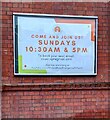
Come And Join Us! Crindau, Newport
Notice on the wall of Malpas Road Evangelical Church https://www.geograph.org.uk/photo/6927304 in August 2021.
Image: © Jaggery
Taken: 9 Aug 2021
0.02 miles
9
Please do not obstruct lane, Ross Lane, Crindau, Newport
The notice faces Goodrich Crescent near the southern end of Ross Lane.
A yellow Neighbourhood Watch notice is also on the lamppost.
Image: © Jaggery
Taken: 3 Jan 2016
0.03 miles
10
Grate Choice nameboard, Malpas Road, Crindau, Newport
Resting on railings near the Grate Choice premises https://www.geograph.org.uk/photo/6927326 in August 2021.
Image: © Jaggery
Taken: 9 Aug 2021
0.03 miles