IMAGES TAKEN NEAR TO
Redland Street, NEWPORT, NP20 5LZ
Introduction
This page details the photographs taken nearby to Redland Street, NP20 5LZ by members of the Geograph project.
The Geograph project started in 2005 with the aim of publishing, organising and preserving representative images for every square kilometre of Great Britain, Ireland and the Isle of Man.

There are currently over 7.5m images from over14,400 individuals and you can help contribute to the project by visiting https://www.geograph.org.uk
Image Map
Images are licensed for reuse under creativecommons.org/licenses/by-sa/2.0
Notes
- Clicking on the map will re-center to the selected point.
- The higher the marker number, the further away the image location is from the centre of the postcode.
Image Listing (1202 Images Found)
Images are licensed for reuse under creativecommons.org/licenses/by-sa/2.0
Image
Details
Distance
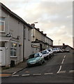
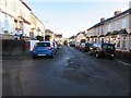
1
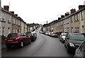
Long lines of cars in Redland Street, Newport
Viewed from the Malpas Road end looking along Redland Street towards Brynglas Avenue.
Image: © Jaggery
Taken: 15 Nov 2015
0.01 miles
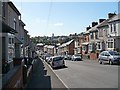
2
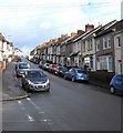
Up Redland Street, Newport
From the corner of Prospect Street, Redland Street ascends
towards Chelston Place, Spring Street and Brynglas Avenue.
Image: © Jaggery
Taken: 17 Feb 2020
0.01 miles
3
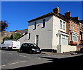
White house on the corner of Chelston Place and Redland Street, Newport
Viewed across Redland Street.
Image: © Jaggery
Taken: 15 Apr 2020
0.02 miles
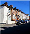
4
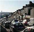
Redland Street, Newport
Houses on the west side of Redland Street, which descends steeply towards Malpas Road.
Redland Street is a continuation of Brynglas Avenue. The continuation is so seamless that 114 Redland Street is next door to 2 Brynglas Avenue in the same block of terraced houses - very confusing for the uninitiated!
Image: © Jaggery
Taken: 1 Jan 2010
0.02 miles
5
Spring Street, Newport
Houses on the south side of Spring Street, viewed from Redland Street looking towards the southern end of Crindau Road.
Image: © Jaggery
Taken: 3 Jan 2010
0.02 miles
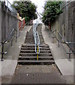
6
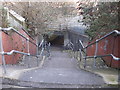
Steps to underpass,Redland Street, Newport
Located opposite Spring Street, the steps descend from the east side of Redland Street to an underpass beneath Heidenheim Drive (A4042). On the other side of the underpass, a short path http://www.geograph.org.uk/photo/1644923 leads to the corner of Aragon Street and Ailesbury Street.
Image: © Jaggery
Taken: 3 Jan 2010
0.02 miles
7
Redland Street
The bottom of the street curves to the right before its junction with Image The tower of Image is prominent on the skyline.
Image: © Robin Drayton
Taken: 9 Sep 2009
0.02 miles
8
Redland Street houses north of Chelston Place, Newport
Row of houses on the west side of Redland Street between Chelston
Place and Spring Street on the ascent towards Brynglas Avenue.
Image: © Jaggery
Taken: 15 Apr 2020
0.03 miles
9
East along Spring Street, Newport
Viewed from the corner of Crindau Road looking towards Redland Street.
Image: © Jaggery
Taken: 30 Dec 2014
0.03 miles
10
Steps up to Redland Street, Newport
From the western end of this https://www.geograph.org.uk/photo/5847417 A4042 underpass.
Image: © Jaggery
Taken: 17 Jul 2018
0.03 miles