IMAGES TAKEN NEAR TO
Redland Street, NEWPORT, NP20 5LS
Introduction
This page details the photographs taken nearby to Redland Street, NP20 5LS by members of the Geograph project.
The Geograph project started in 2005 with the aim of publishing, organising and preserving representative images for every square kilometre of Great Britain, Ireland and the Isle of Man.

There are currently over 7.5m images from over14,400 individuals and you can help contribute to the project by visiting https://www.geograph.org.uk
Image Map
Images are licensed for reuse under creativecommons.org/licenses/by-sa/2.0
Notes
- Clicking on the map will re-center to the selected point.
- The higher the marker number, the further away the image location is from the centre of the postcode.
Image Listing (1080 Images Found)
Images are licensed for reuse under creativecommons.org/licenses/by-sa/2.0
Image
Details
Distance
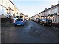
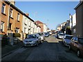
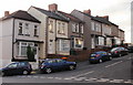
1
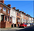
West side of Redland Street, Newport
Row of houses north of the Spring Street junction on the ascent towards Brynglas Avenue.
Image: © Jaggery
Taken: 15 Apr 2020
0.02 miles
2

Crindau site for new Sainsbury superstore, Newport
This view across the former Crindau Gasworks site, taken in mid-December 2009 from the Albany Street edge of the site, shows blue portakabins in place at the other (A4042) side of the site, about 200 metres away. Presumably work will begin soon on the transformation of the site into a Sainsbury superstore, scheduled to open in December 2010.
Image: © Jaggery
Taken: 14 Dec 2009
0.03 miles
3
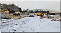
Work in progress on Crindau site of new Sainsbury superstore
It's mid-January 2010, and excavation work has begun on the former gasworks site in Crindau. A Sainsbury's superstore is to be built here. The superstore is expected to be open for business in late 2010.
This view is from Aragon Street.
Image: © Jaggery
Taken: 15 Jan 2010
0.03 miles
4
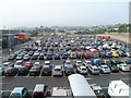
Sainsbury's car park, Crindau, Newport
This site was previously derelict ground, and before that, decades ago, a gas company's premises.
The large car park is between the superstore on the left, and the A4042 on the right. There are 685 parking spaces, 31 disabled parking spaces and 23 parent and child parking spaces. Shoppers are allowed up to 3 hours of free parking.
Image: © Jaggery
Taken: 22 Sep 2010
0.03 miles
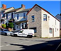
5
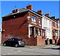
House on the corner of Redland Street and Spring Street, Newport
Viewed across Redland Street.
Image: © Jaggery
Taken: 15 Apr 2020
0.03 miles
6
East along Spring Street, Newport
Viewed from the corner of Crindau Road looking towards Redland Street.
Image: © Jaggery
Taken: 30 Dec 2014
0.03 miles
7
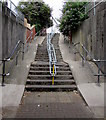
Steps up to Redland Street, Newport
From the western end of this https://www.geograph.org.uk/photo/5847417 A4042 underpass.
Image: © Jaggery
Taken: 17 Jul 2018
0.03 miles
8
House on the corner of Brynglas Crescent and Brynglas Avenue, Newport
The vehicles are parked in Brynglas Crescent. At this junction, Redland Street on the camera side becomes Brynglas Avenue. Nearby, 114 Redland Street is next door to 2 Brynglas Avenue in the same row of houses.
Image: © Jaggery
Taken: 15 Apr 2020
0.04 miles
9
Looking up Crindau Road, Newport
The view from the corner of Spring Street, looking towards Brynglas Crescent.
Image: © Jaggery
Taken: 1 Jan 2010
0.04 miles
10
Brynglas Crescent, Newport
Houses on the south side of Brynglas Crescent, a short road whose western end connects with Crindau Road. The eastern end of Brynglas Crescent connects with the point where the top end of Redland Street becomes the lower end of Brynglas Avenue. http://www.geograph.org.uk/photo/2046750 to the other side of the street.
Image: © Jaggery
Taken: 3 Jan 2010
0.04 miles