IMAGES TAKEN NEAR TO
Queens Hill Crescent, NEWPORT, NP20 5HG
Introduction
This page details the photographs taken nearby to Queens Hill Crescent, NP20 5HG by members of the Geograph project.
The Geograph project started in 2005 with the aim of publishing, organising and preserving representative images for every square kilometre of Great Britain, Ireland and the Isle of Man.

There are currently over 7.5m images from over14,400 individuals and you can help contribute to the project by visiting https://www.geograph.org.uk
Image Map
Images are licensed for reuse under creativecommons.org/licenses/by-sa/2.0
Notes
- Clicking on the map will re-center to the selected point.
- The higher the marker number, the further away the image location is from the centre of the postcode.
Image Listing (328 Images Found)
Images are licensed for reuse under creativecommons.org/licenses/by-sa/2.0
Image
Details
Distance
1
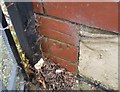
Ordnance Survey Cut Mark
This OS cut mark can be found on No88 Queens Hill Crescent. It marks a point 33.601m above mean sea level.
Image: © Adrian Dust
Taken: 17 Jun 2018
0.04 miles
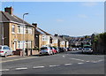
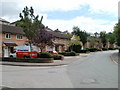
2
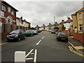
Queen's Hill Crescent, Newport
Viewed from the edge of Queen's Hill
Image: © Jaggery
Taken: 16 Aug 2009
0.05 miles
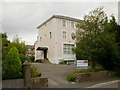
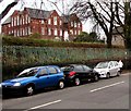
4
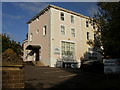
15 Gold Tops, Newport
Since this photo, http://www.geograph.org.uk/photo/1448570 taken 4 months previously, the building has become the premises of Crystal Cleaning Solutions.
Image: © Jaggery
Taken: 12 Dec 2009
0.07 miles
5
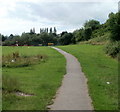
Path from Harlequin Drive to Sorrel Drive, Newport
The path is through an open space on the edge of Barrack Hill. Ahead is a recreation area, and beyond, Sorrel Drive. http://www.geograph.org.uk/photo/1981026
Image: © Jaggery
Taken: 25 Jul 2010
0.09 miles
6
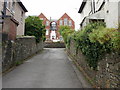
Entrance to St Mary's RC primary school, Newport
The entrance road is from Queen's Hill. Part of the school is visible at the top of the road.
Image: © Jaggery
Taken: 16 Aug 2009
0.09 miles
7
Queen's Hill Crescent, Allt-yr-yn, Newport
Queen's Hill Crescent descends from the north side of St Mark's Crescent.
Image: © Jaggery
Taken: 17 Aug 2016
0.09 miles
8
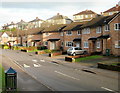
Sorrel Drive, Newport
Sorrel Drive is the principal road through Barrack Fields, a recent housing development in Allt-yr-yn. This view, of houses on the east side, is from near the Coltsfoot Close junction, looking towards the Comfrey Close junction. Behind the houses, about 30 metres away and at a higher elevation, are houses in Queen's Hill Crescent.
Image: © Jaggery
Taken: 10 Dec 2009
0.10 miles
9
Sorrel Drive, Newport
Sorrel Drive is the principal road through Barrack Fields, a recent housing development in Allt-yr-yn. This view is from the north end of the street, adjacent to an open space http://www.geograph.org.uk/photo/1981020 and a path to Harlequin Drive.
Image: © Jaggery
Taken: 25 Jul 2010
0.10 miles
10
St Mary's RC primary school, Newport
Roman Catholic primary school set back from, and above, the west side of Queen's Hill.
Image: © Jaggery
Taken: 26 Nov 2015
0.11 miles