1
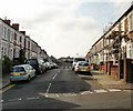
Harlequin Drive from the east, Newport
Viewed from the corner of Barrack Hill. The far end of the street http://www.geograph.org.uk/photo/1981011 leads to an open space.
Image: © Jaggery
Taken: 25 Jul 2010
0.02 miles
2
Harlequin Drive from the west, Newport
Viewed from the edge of an open space, on a path leading to Sorrel Drive.
The far end of Harlequin Drive connects with Barrack Hill. http://www.geograph.org.uk/photo/1981005
Image: © Jaggery
Taken: 25 Jul 2010
0.02 miles
3
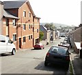
West along Harlequin Drive, Newport
From Barrack Hill, Harlequin Drive leads to Harlequin Court.
Image: © Jaggery
Taken: 29 Jul 2021
0.05 miles
4
Hopefield, Newport
Looking up Hopefield from Dos Road towards Power Street.
Image: © Jaggery
Taken: 16 Aug 2009
0.05 miles
5
Belvedere Terrace, Newport
The view along Belvedere Terrace from the corner of Barrack Hill, looking towards Hopefield.
Image: © Jaggery
Taken: 18 Sep 2009
0.05 miles
6
Hopefield, Newport
Hopefield descends from Power Street towards Dos Road. The turning on the left is for Belvedere Terrace. http://www.geograph.org.uk/photo/1729409
Image: © Jaggery
Taken: 18 Sep 2009
0.05 miles
7
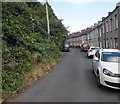
One-sided Power Street, Newport
The houses on the east side of Power Street are opposite trees and bushes at the bottom of a steep slope.
Image: © Jaggery
Taken: 8 Sep 2016
0.05 miles
8
Corner of Harlequin Drive and Barrack Hill, Newport
Image: © Jaggery
Taken: 25 Jul 2010
0.05 miles
9
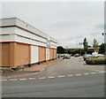
Entrance to Discovery Park, Newport
Viewed across Barrack Hill. The entrance is to a small retail park http://www.geograph.org.uk/photo/1611173 containing two shops. One is Aldi, the other is Wickes, part of whose premises are on the left.
Image: © Jaggery
Taken: 25 Jul 2010
0.05 miles
10
Bend in Power Street, Newport
Viewed from near the dead end of Power Street looking to the NE towards Barrack Hill.
Image: © Jaggery
Taken: 8 Sep 2016
0.06 miles


