IMAGES TAKEN NEAR TO
Power Street, NEWPORT, NP20 5FS
Introduction
This page details the photographs taken nearby to Power Street, NP20 5FS by members of the Geograph project.
The Geograph project started in 2005 with the aim of publishing, organising and preserving representative images for every square kilometre of Great Britain, Ireland and the Isle of Man.

There are currently over 7.5m images from over14,400 individuals and you can help contribute to the project by visiting https://www.geograph.org.uk
Image Map
Images are licensed for reuse under creativecommons.org/licenses/by-sa/2.0
Notes
- Clicking on the map will re-center to the selected point.
- The higher the marker number, the further away the image location is from the centre of the postcode.
Image Listing (967 Images Found)
Images are licensed for reuse under creativecommons.org/licenses/by-sa/2.0
Image
Details
Distance
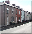
1
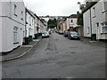
Hopefield, Newport
Looking up Hopefield from Dos Road towards Power Street.
Image: © Jaggery
Taken: 16 Aug 2009
0.01 miles
2
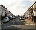
Belvedere Terrace, Newport
The view along Belvedere Terrace from the corner of Barrack Hill, looking towards Hopefield.
Image: © Jaggery
Taken: 18 Sep 2009
0.01 miles
3
Hopefield, Newport
Hopefield descends from Power Street towards Dos Road. The turning on the left is for Belvedere Terrace. http://www.geograph.org.uk/photo/1729409
Image: © Jaggery
Taken: 18 Sep 2009
0.01 miles
4
Power Street electricity substation, Newport
The Western Power Distribution electricity substation identifier is S/S 532250.
Image: © Jaggery
Taken: 8 Sep 2016
0.01 miles
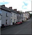
5
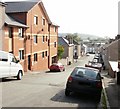
Power Street houses south of Hopefield, Newport
The Hopefield http://www.geograph.org.uk/photo/5115110 junction is on the left.
Image: © Jaggery
Taken: 8 Sep 2016
0.01 miles
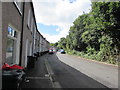
6
Bend in Power Street, Newport
Viewed from near the dead end of Power Street looking to the NE towards Barrack Hill.
Image: © Jaggery
Taken: 8 Sep 2016
0.02 miles
7
Hopefield ascends towards Power Street, Newport
Viewed from the corner of Belvedere Terrace in the Barrack Hill area of Newport
Image: © Jaggery
Taken: 8 Sep 2016
0.04 miles
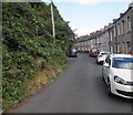
8
Up Hopefield, Newport
Hopefield ascends from Dos Road to Power Street in the Barrack Hill area of Newport.
Image: © Jaggery
Taken: 8 Sep 2016
0.04 miles
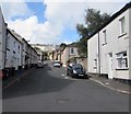
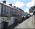
9
One-sided Power Street, Newport
The houses on the east side of Power Street are opposite trees and bushes at the bottom of a steep slope.
Image: © Jaggery
Taken: 8 Sep 2016
0.04 miles
10
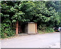
Upper Power Street, Newport
Between Lambert Street and Power Street. According to one online reference,
this is the only Upper Power Street in the UK.
Image: © Jaggery
Taken: 8 Sep 2016
0.04 miles