IMAGES TAKEN NEAR TO
Belvedere Terrace, NEWPORT, NP20 5FQ
Introduction
This page details the photographs taken nearby to Belvedere Terrace, NP20 5FQ by members of the Geograph project.
The Geograph project started in 2005 with the aim of publishing, organising and preserving representative images for every square kilometre of Great Britain, Ireland and the Isle of Man.

There are currently over 7.5m images from over14,400 individuals and you can help contribute to the project by visiting https://www.geograph.org.uk
Image Map
Images are licensed for reuse under creativecommons.org/licenses/by-sa/2.0
Notes
- Clicking on the map will re-center to the selected point.
- The higher the marker number, the further away the image location is from the centre of the postcode.
Image Listing (1139 Images Found)
Images are licensed for reuse under creativecommons.org/licenses/by-sa/2.0
Image
Details
Distance
1
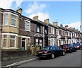
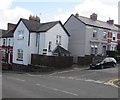
Stone houses, Belvedere Terrace, Newport
This part of Belvedere Terrace is near the Hopefield junction in the Barrack Hill area of Newport.
Image: © Jaggery
Taken: 8 Sep 2016
0.01 miles
2
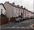
Houses on the east side of Belvedere Terrace, Newport
Viewed from Barrack Hill looking towards Hopefield.
Image: © Jaggery
Taken: 19 Dec 2013
0.02 miles
3
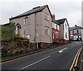
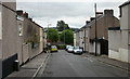
Up Barrack Hill towards Belvedere Terrace, Newport
Barrack Hill is one of the steepest streets in Newport.
Image: © Jaggery
Taken: 19 Dec 2013
0.02 miles
4
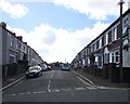
Junction of Barrack Hill and Belvedere Terrace, Newport
Looking south along Belvedere Terrace from Barrack Hill.
Image: © Jaggery
Taken: 8 Sep 2016
0.02 miles
5
Corner of Barrack Hill and Belvedere Terrace, Newport
Viewed across Barrack Hill.
Image: © Jaggery
Taken: 8 Sep 2016
0.02 miles
6
Dos Road, Newport
Looking from the Canal Street junction towards Barrack Hill.
Image: © Jaggery
Taken: 16 Aug 2009
0.03 miles
7
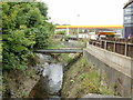
Disused canal bridge, Crindau, Newport
Now partly overgrown with vegetation, this disused bridge across the Monmouthshire & Brecon canal formerly gave a shortcut from Barrack Hill to Malpas Road.
Image: © Jaggery
Taken: 6 Sep 2009
0.03 miles
8
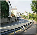
The view up Barrack Hill, Newport
Viewed from the bend adjacent to the Monmouthshire & Brecon Canal.
Formerly, Barrack Hill continued on down in a straight line past this point to connect directly with Shaftesbury Street and Malpas Road.
Image: © Jaggery
Taken: 18 Sep 2009
0.03 miles
9
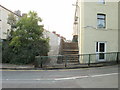
Steps from Barrack Hill to Dos Road, Newport
The Barrack Hill end of Dos Road is blocked off to prevent vehicular access. Pedestrians can use the steps.
Image: © Jaggery
Taken: 18 Sep 2009
0.03 miles
10
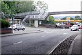
Steps to footbridge, Crindau, Newport
Steps lead up to a footbridge across Malpas Road. The steps occupy land formerly crossed by the end of the road named Barrack Hill, at the junction with Malpas Road. Nowadays, the route of Barrack Hill extends to a roundabout adjacent to Queen's Hill.
Image: © Jaggery
Taken: 11 Jul 2010
0.03 miles