IMAGES TAKEN NEAR TO
Queens Hill, NEWPORT, NP20 5FE
Introduction
This page details the photographs taken nearby to Queens Hill, NP20 5FE by members of the Geograph project.
The Geograph project started in 2005 with the aim of publishing, organising and preserving representative images for every square kilometre of Great Britain, Ireland and the Isle of Man.

There are currently over 7.5m images from over14,400 individuals and you can help contribute to the project by visiting https://www.geograph.org.uk
Image Map
Images are licensed for reuse under creativecommons.org/licenses/by-sa/2.0
Notes
- Clicking on the map will re-center to the selected point.
- The higher the marker number, the further away the image location is from the centre of the postcode.
Image Listing (1203 Images Found)
Images are licensed for reuse under creativecommons.org/licenses/by-sa/2.0
Image
Details
Distance
1
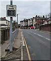
Your speed indicator, Queen's Hill, Newport
Currently off, the display turns on to show the speed in green if an
approaching vehicle is within the speed limit, or red if over the speed limit.
Image: © Jaggery
Taken: 28 Jan 2023
0.01 miles
2

Colourful mural, Queen's Hill, Newport
On a wall opposite the Queen's Hill Crescent junction in January 2023.
Image: © Jaggery
Taken: 28 Jan 2023
0.01 miles
3
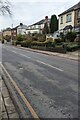
Queen's Hill houses, Newport
This part of Queen's Hill is between Queen's Croft and Queen's Hill Crescent.
Image: © Jaggery
Taken: 28 Jan 2023
0.02 miles
4
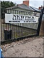
Newpack Export Packers name sign, Newport
Facing Queen's Hill in January 2023.
Image: © Jaggery
Taken: 28 Jan 2023
0.02 miles
5
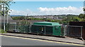
Queens Hill electricity substation set below road level, Newport
Though located at the edge of the road named Queens Hill, the Western Power Distribution electricity substation's identifier is Pentonville S/S 53-2502. The nearest part of the street named Pentonville is nearly 300 metres to the south.
Image: © Jaggery
Taken: 8 Jun 2014
0.02 miles
6
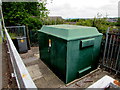
Queen's Hill electricity substation below road level, Newport
Though below the road named Queen's Hill, the Western Power Distribution electricity substation's identifier is Pentonville S/S 53-2502. The nearest part of the street named Pentonville is nearly 300 metres away.
Image: © Jaggery
Taken: 21 May 2017
0.02 miles
7
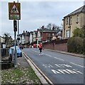
Bilingual warning sign, Queen's Hill, Newport
Grimy in January 2023, the sign shows Patrol and the Welsh Hebryngwr.
A primary school is ahead.
Image: © Jaggery
Taken: 28 Jan 2023
0.02 miles
8
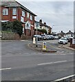
Junction of Queen's Hill Crescent and Queen's Hill, Newport
Viewed across Queen's Hill.
Image: © Jaggery
Taken: 28 Jan 2023
0.02 miles
9
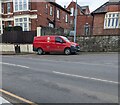
Royal Mail van, Queen's Hill, Newport
Parked while its driver https://www.geograph.org.uk/photo/7406355 delivers letters and small parcels to nearby houses in January 2023.
Image: © Jaggery
Taken: 28 Jan 2023
0.03 miles
10
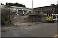
Fenced-off site, Factory Road, Newport
In February 2017, temporary fencing blocks the entrance to the Newpack site.
The Site Safety Notice http://www.geograph.org.uk/photo/5279364 on the fencing shows WARNING CONSTRUCTION IN PROGRESS
and Unauthorised entry to this site is strictly prohibited.
Image: © Jaggery
Taken: 11 Feb 2017
0.03 miles