IMAGES TAKEN NEAR TO
Rose Street, NEWPORT, NP20 5FD
Introduction
This page details the photographs taken nearby to Rose Street, NP20 5FD by members of the Geograph project.
The Geograph project started in 2005 with the aim of publishing, organising and preserving representative images for every square kilometre of Great Britain, Ireland and the Isle of Man.

There are currently over 7.5m images from over14,400 individuals and you can help contribute to the project by visiting https://www.geograph.org.uk
Image Map
Images are licensed for reuse under creativecommons.org/licenses/by-sa/2.0
Notes
- Clicking on the map will re-center to the selected point.
- The higher the marker number, the further away the image location is from the centre of the postcode.
Image Listing (2029 Images Found)
Images are licensed for reuse under creativecommons.org/licenses/by-sa/2.0
Image
Details
Distance
1
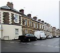
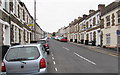
West side of Rose Street, Newport
Row of 19th century houses viewed from Locke Street.
Image: © Jaggery
Taken: 4 Nov 2015
0.01 miles
2

Factory Road entrance to Royal Mail premises
The entrance to Royal Mail's Newport West Delivery Office.
Image: © Jaggery
Taken: 12 Dec 2009
0.02 miles
3
Corner of Lucas Street and Factory Road, Newport
Houses on the south side of Lucas Street, viewed across Factory Road. The corner house has both the current-style street name sign supported on two black legs, and an older-style sign located at the level of the bottom of the upstairs windows.
Image: © Jaggery
Taken: 11 Apr 2011
0.02 miles
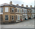
4
Cars and houses, Rose Street, Newport
On the ascent from Lucas Street to Locke Street.
Image: © Jaggery
Taken: 28 Jan 2023
0.02 miles
5

Benchmark on house at junction of Lucas Street and Rose Street
Ordnance Survey cut mark benchmark described on the Bench Mark Database at http://www.bench-marks.org.uk/bm35086
Image: © Roger Templeman
Taken: 5 Aug 2010
0.02 miles
6
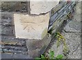
Ordnance Survey Cut Mark
This OS cut mark can be found on No29 Lucus Street. It marks a point 18.652m above mean sea level.
Image: © Adrian Dust
Taken: 17 Jun 2018
0.02 miles
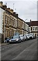
7
Up Locke Street, Newport
Ascending from Factory Road towards Queen's Hill. A No Through Road sign is on the right.
Locke Street was formerly a through route for motor vehicles. In 2015, there are concrete posts across Locke Street near the Rose Street junction. The cars in the distance are parked at the edge of the posts.
Image: © Jaggery
Taken: 16 Oct 2015
0.03 miles
8
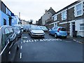
Parking area at the top of Locke Street, Newport
Formerly a through route for motor vehicles from Factory Road to Queen's Hill,
Locke Street is now blocked by concrete posts across the road.
Two of the posts are in view, one on each side of the grey car.
Queen's Hill is ahead, about 60 metres from the camera.
Image: © Jaggery
Taken: 16 Nov 2015
0.03 miles
9

Up Locke Street, Newport
From Factory Road, Locke Street ascends towards Queen's Hill.
Image: © Jaggery
Taken: 28 Jan 2023
0.03 miles
10
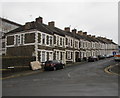
Long row of houses, Locke Street, Newport
The south side of Locke Street viewed from Factory Road.
Image: © Jaggery
Taken: 11 Feb 2017
0.03 miles