1
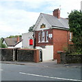
Entrance to Nant Coch church, Newport
The church http://www.geograph.org.uk/photo/1987139 is set back from the road and partly hidden by trees, so despite the name board outside, it's easy to miss the turning if you're not sure exactly where it is - which is on Fields Park Road, just a few metres west of the turning for Kings Acre and a few metres east of the turning for the western part of Fields Park Avenue.
Image: © Jaggery
Taken: 25 Jul 2010
0.02 miles
2
Nant Coch church, Newport
Located at 68 Fields Park Road. Nant Coch is an Evangelical Christian Fellowship which was formed in 1942. It met originally at Nant Coch House on Risca Road, now Rougemont School.
Image: © Jaggery
Taken: 25 Jul 2010
0.02 miles
3
1-5 Kings Acre, Newport
Kings Acre is a development of houses and flats built c1999 on the south side of Fields Park Road.
Seen here are 1-5 Kings Acre.
Image: © Jaggery
Taken: 25 Jul 2010
0.02 miles
4
St Catherine's Nursing Home, Newport
Located at 59 Fields Park Road. Privately owned care home with nursing, accommodating 30 residents.
Image: © Jaggery
Taken: 25 Jul 2010
0.02 miles
5
Nant Coch Church
An evangelical Christian church in Fields Park Road.
Image: © Rod Allday
Taken: 7 May 2015
0.03 miles
6
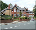
Fields Park Road houses, Newport
Houses on the north side of Fields Park Road, east of Kings Acre. http://www.geograph.org.uk/photo/1987249
Image: © Jaggery
Taken: 25 Jul 2010
0.05 miles
7
Penderyn, 48 Fields Park Road, Newport
In common with almost all streets in Newport, houses in Fields Park Road now have numbers. Kelly's Directory of 1901 shows no numbers for this and adjacent houses, only names.
It is interesting to speculate which of several Penderyns inspired the name.
Penderyn is a village
Image in Rhondda Cynon Taf, or a type of whisky made in Wales since the 19th century.
Another possibility is Dic Penderyn, born 1808, who was treated as a martyr across Britain after he was hanged in 1831 on what were widely considered to be trumped-up charges of stabbing a soldier during the 1831 Merthyr Uprising.
Image: © Jaggery
Taken: 25 Jul 2010
0.05 miles
8
Kings Acre, Newport
Kings Acre is a development of houses and flats, built c1999, on the south side of Fields Park Road.
Image: © Jaggery
Taken: 25 Jul 2010
0.05 miles
9
Edward VII Avenue, Newport
Autumn colour from plane trees.
Image: © Robin Drayton
Taken: 23 Oct 2013
0.07 miles
10
Edward VII Avenue, Newport
Autumn colour from plane trees.
Image: © Robin Drayton
Taken: 23 Oct 2013
0.07 miles


