IMAGES TAKEN NEAR TO
Stow Hill, NEWPORT, NP20 4SZ
Introduction
This page details the photographs taken nearby to Stow Hill, NP20 4SZ by members of the Geograph project.
The Geograph project started in 2005 with the aim of publishing, organising and preserving representative images for every square kilometre of Great Britain, Ireland and the Isle of Man.

There are currently over 7.5m images from over14,400 individuals and you can help contribute to the project by visiting https://www.geograph.org.uk
Image Map
Images are licensed for reuse under creativecommons.org/licenses/by-sa/2.0
Notes
- Clicking on the map will re-center to the selected point.
- The higher the marker number, the further away the image location is from the centre of the postcode.
Image Listing (592 Images Found)
Images are licensed for reuse under creativecommons.org/licenses/by-sa/2.0
Image
Details
Distance
1
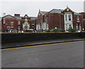
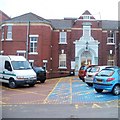
North side of St Woolos Hospital, Newport
Viewed across from Stow Hill. The buildings are dated 1902.
At that time, this was the Newport Workhouse.
Image: © Jaggery
Taken: 19 Mar 2020
0.01 miles
2
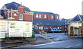
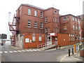
Northern entrance to St Woolos Hospital, Newport
On Stow Hill, just west of St Woolos Cathedral. For many decades, until the 1930s, this was one of the most feared locations in Newport. As Woolaston House, it was Newport Workhouse.
Workhouses were used for poor relief in the Victorian era (and later) throughout the UK. They were places of dread for the needy poor and elderly, who had no alternatives in the days before the Welfare State. Books such as Charles Dickens' Oliver Twist highlighted conditions in the workhouse.
Workhouse life was deliberately made as harsh and degrading as possible so that only the truly destitute would apply.
The southern entrance http://www.geograph.org.uk/photo/1473698 to the hospital, from Friars Road, is at an elevation about 15 metres (50 feet) lower than this entrance.
Image: © Jaggery
Taken: 20 Dec 2009
0.01 miles
3
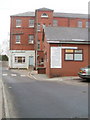
Sunhealth Gym, Newport
134 Stow Hill, opposite St Woolos Hospital.
Image: © Jaggery
Taken: 20 Dec 2009
0.01 miles
4
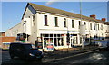
Gwent Camping, Stow Hill, Newport
Suppliers of camping and outdoor equipment, at 136-140 Stow Hill, opposite St Woolos Hospital.
Image: © Jaggery
Taken: 20 Dec 2009
0.01 miles
5
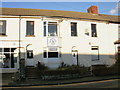
Main doorway into St Woolos Hospital, Newport
The doorway into the hospital is a few metres from the entrance road http://www.geograph.org.uk/photo/1628503 from Stow Hill. The date in stone above the entrance is 1902. At that time, this was the Newport Workhouse.
Image: © Jaggery
Taken: 14 Jan 2011
0.01 miles
6
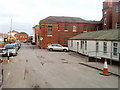
Eastern perimeter road, St Woolos Hospital, Newport
A few metres beyond the entrance http://www.geograph.org.uk/photo/1628503 from Stow Hill, a large sign on a wall shows 20 locations, some to the right, some to the left along the road that descends to lower levels. The hospital occupies a steep roughly triangular site between Stow Hill on the north side, Friars Road to the south and east, and Stow Park Avenue to the west.
Image: © Jaggery
Taken: 23 Jan 2011
0.01 miles
7
Orthopedic Assessment Unit, St Woolos Hospital, Newport
The entrance to the unit is alongside the eastern perimeter road. In the left background is the boiler house chimney. http://www.geograph.org.uk/photo/2243444
Image: © Jaggery
Taken: 23 Jan 2011
0.01 miles
8
Northern perimeter road, St Woolos Hospital, Newport
The hospital road runs parallel with Stow Hill, separated from it by the perimeter wall, just out of shot on the left.
Image: © Jaggery
Taken: 29 Jan 2011
0.01 miles
9
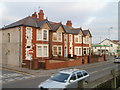
Newport : Stow Hill houses on the corner of Brynhyfryd Avenue
A row of four houses on Stow Hill located between the turning into Brynhyfryd Avenue on the left, and a service station.
Image: © Jaggery
Taken: 29 Jan 2011
0.01 miles
10
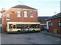
Newport Bus vehicle 98 on route 98, St Woolos Hospital, Newport
The bus is stopped at the bus stop at the Stow Hill entrance/exit http://www.geograph.org.uk/photo/1628503 to St Woolos Hospital. In a few seconds it will descend along the eastern edge of the hospital to a stop http://www.geograph.org.uk/photo/2253526 near the Friars Road entrance/exit. The bus is on Newport Bus route 98 from the central bus station. Coincidentally, this vehicle's Newport Bus fleet number is also 98.
Image: © Jaggery
Taken: 17 Feb 2011
0.01 miles