IMAGES TAKEN NEAR TO
Gold Tops, NEWPORT, NP20 4PG
Introduction
This page details the photographs taken nearby to Gold Tops, NP20 4PG by members of the Geograph project.
The Geograph project started in 2005 with the aim of publishing, organising and preserving representative images for every square kilometre of Great Britain, Ireland and the Isle of Man.

There are currently over 7.5m images from over14,400 individuals and you can help contribute to the project by visiting https://www.geograph.org.uk
Image Map
Images are licensed for reuse under creativecommons.org/licenses/by-sa/2.0
Notes
- Clicking on the map will re-center to the selected point.
- The higher the marker number, the further away the image location is from the centre of the postcode.
Image Listing (2049 Images Found)
Images are licensed for reuse under creativecommons.org/licenses/by-sa/2.0
Image
Details
Distance
1
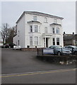
Pagefield House, 24 Gold Tops, Newport
In April 2016 the nameboard on railings shows Abbeyfield Wales Society Ltd.
Image: © Jaggery
Taken: 13 Apr 2016
0.00 miles
2
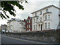
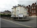
Gold Tops
Most of the large houses in this area are occupied by firms offering business and financial services.
Image: © Robin Drayton
Taken: 13 Jun 2008
0.01 miles
3
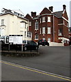
Information board on the north side of Gold Tops, Newport
The board shows the various businesses in 22, 23, 23A, 24 and 24A Gold Tops in April 2016.
Image: © Jaggery
Taken: 13 Apr 2016
0.02 miles
4
23 and 23A Gold Tops Newport
Located near the Stanley Road end of Gold Tops. Occupiers listed on the board outside the premises :
R.E. Phillips & Partners
Newbridge Construction Ltd.
Llanover Estate
Llanarth Estate
Tredegar Estate
Llanover Properties
Pontymister Developments Ltd.
Image: © Jaggery
Taken: 16 Aug 2009
0.02 miles
5
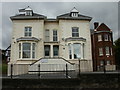
22 Gold Tops Newport
Viewed from the Stanley Road side. http://www.geograph.org.uk/photo/1448400 for front view. The occupiers shown on the board are
East Wales Valuation Tribunal
South Wales Valuation Tribunal
Image: © Jaggery
Taken: 16 Aug 2009
0.02 miles
6
22 Gold Tops Newport front view
Occupiers are shown on a nameboard outside the building as
East Wales Valuation Tribunal
South Wales Valuation Tribunal
See http://www.geograph.org.uk/photo/1448388 for different view
Image: © Jaggery
Taken: 16 Aug 2009
0.02 miles
7
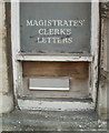
Overworked Victorian clerk? Newport
A faded sign above a letterbox on the north side of the former magistrates' court http://www.geograph.org.uk/photo/895526 refers to Magistrates' Clerk's Letters.
If the (possibly Victorian) signwriter was punctilious in the use of punctuation, at the time of the sign's creation, there was more than one magistrate, but only one clerk. My knowledge of the typical amount of clerical work generated by magistrates then (or indeed now) is insufficient to judge how well one clerk could have coped.
Image: © Jaggery
Taken: 25 Jul 2010
0.02 miles
8
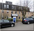
Network Rail office, One Gold Tops, Newport
In April 2016 a banner shows South Wales Mainline Electrification Programme Office.
Image: © Jaggery
Taken: 13 Apr 2016
0.02 miles
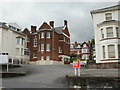
9

Grade II Listed building at the eastern end of Gold Tops, Newport
Built as the Tredegar Estates office (1905) https://www.geograph.org.uk/photo/3236437 the building was later used as a magistrates court. Now in use as offices. Grade II Listed in 1980 as an impressively designed former estate office which has retained its original character and detail.
Image: © Jaggery
Taken: 13 Apr 2016
0.02 miles
10
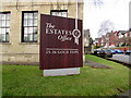
The Estates Office nameboard, 25-26 Gold Tops, Newport
On the right here. https://www.geograph.org.uk/photo/6340281
Image: © Jaggery
Taken: 13 Apr 2016
0.03 miles