IMAGES TAKEN NEAR TO
Devon Place, NEWPORT, NP20 4NW
Introduction
This page details the photographs taken nearby to Devon Place, NP20 4NW by members of the Geograph project.
The Geograph project started in 2005 with the aim of publishing, organising and preserving representative images for every square kilometre of Great Britain, Ireland and the Isle of Man.

There are currently over 7.5m images from over14,400 individuals and you can help contribute to the project by visiting https://www.geograph.org.uk
Image Map
Images are licensed for reuse under creativecommons.org/licenses/by-sa/2.0
Notes
- Clicking on the map will re-center to the selected point.
- The higher the marker number, the further away the image location is from the centre of the postcode.
Image Listing (2228 Images Found)
Images are licensed for reuse under creativecommons.org/licenses/by-sa/2.0
Image
Details
Distance
1
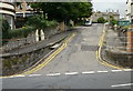
Ramp up to an elevated pavement, Devon Place, Newport
About a metre above the road, the elevated pavement extends to the Stanley Road junction.
Image: © Jaggery
Taken: 6 May 2021
0.02 miles
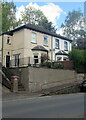
2

Ordnance Survey Cut Mark
This OS cut mark can be found on the wall of No38 Devon Place. It marks a point 18.416m above mean sea level.
Image: © Adrian Dust
Taken: 25 May 2015
0.02 miles
3
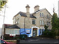
24 Gold Tops , Newport
Pagefield House, currently occupied by Haines Watts, Chartered Accountants.
Image: © Jaggery
Taken: 16 Aug 2009
0.02 miles
4
3 Gold Tops, Newport
Currently occupied by Purnells, Chartered Accountants & Licensed Insolvency Practitioners.
Image: © Jaggery
Taken: 16 Aug 2009
0.02 miles
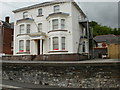
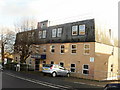
5
1 Gold Tops, Newport
Current occupiers include Midas Construction Ltd. http://www.geograph.org.uk/photo/1614700 for the view four months later, and an update on the occupancy.
Image: © Jaggery
Taken: 16 Aug 2009
0.02 miles
6
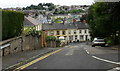
Looking down Stanley Road, Newport
Stanley Road is a candidate for the steepest road in Newport. It rises from 17.6 metres at its base in Devon Place to 28.8 metres at its junction with Gold Tops. The horizontal distance covered (as shown on a map ) is 59 metres, which gives a gradient of 1 in 5.3
As can be seen here, it joins Devon Place at a T junction, so in my younger, cycling, days it was one of the 'impossible' gradients, as a 'flying start' is not possible. It was not a hill to cycle down either, except with brakes engaged.
Fortunately, Stanley Road is not an essential link in the Newport road network.
A short detour via Pentonville avoids the excessive steepness. The view from the bottom http://www.geograph.org.uk/photo/1596720
Image: © Jaggery
Taken: 16 Aug 2009
0.02 miles
7
Looking up Stanley Road, Newport
See http://www.geograph.org.uk/photo/1596713 for the view looking down Stanley Road, and details of its gradient.
Image: © Jaggery
Taken: 16 Aug 2009
0.02 miles
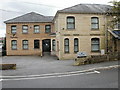
8
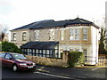
Summit House, 5 Gold Tops, Newport
The signs on the wall list 3 occupants of the premises
Parker & Co, accountants
Citylegal, solicitors
Ietech, network technology business support.
Image: © Jaggery
Taken: 10 Dec 2009
0.02 miles
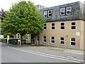
9
4 Gold Tops, Newport
There were no signs to indicate occupancy of these premises at the date of this photo, December 10th 2009.
An Internet search found that the 2,558 square feet (238 square metres) property is for sale at an asking price of £400,000, or for rent at £13.50 per square foot. The property has a mixture of open-plan offices, standard offices and meeting rooms.
Image: © Jaggery
Taken: 10 Dec 2009
0.02 miles
10
1 Gold Tops, Newport
Almost all the front of the building can be seen in this photo taken in December, in contrast to one http://www.geograph.org.uk/photo/1519397 taken in mid August.
The only nameplate above the letterbox at the time of this (December 10th 2009) photo was for Newport Unlimited, Newport's Urban Regeneration Company. The larger nameplates that can be seen on the edge of the pavement are for the Bank of Wales, which ceased trading in 2002, and Midas Construction, whose website shows no office in Newport.
Image: © Jaggery
Taken: 10 Dec 2009
0.02 miles