IMAGES TAKEN NEAR TO
Devon Place, NEWPORT, NP20 4NN
Introduction
This page details the photographs taken nearby to Devon Place, NP20 4NN by members of the Geograph project.
The Geograph project started in 2005 with the aim of publishing, organising and preserving representative images for every square kilometre of Great Britain, Ireland and the Isle of Man.

There are currently over 7.5m images from over14,400 individuals and you can help contribute to the project by visiting https://www.geograph.org.uk
Image Map
Images are licensed for reuse under creativecommons.org/licenses/by-sa/2.0
Notes
- Clicking on the map will re-center to the selected point.
- The higher the marker number, the further away the image location is from the centre of the postcode.
Image Listing (1962 Images Found)
Images are licensed for reuse under creativecommons.org/licenses/by-sa/2.0
Image
Details
Distance
1
South side of the Platform office building, Newport
Viewed from an entrance to Newport railway station. http://www.geograph.org.uk/photo/4703454 to a view from Devon Place.
Image: © Jaggery
Taken: 16 Oct 2015
0.01 miles
2
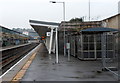
Sloping canopy, platform 4, Newport railway station
The slope of the canopy supports contrasts with the vertical lamppost and shelter, one of several shelters on this platform. Platform 4 is generally used for trains to the north, south and the West Country. Most departures for London Paddington use platform 3, with trains west to Cardiff and beyond generally using platform 2. There is some flexibility (and late platform changes) when a train is delayed. Platform 1 is used for a few trains to Cardiff.
Image: © Jaggery
Taken: 10 Oct 2012
0.01 miles
3
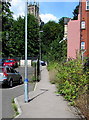
Footpath to Devon Place, Newport
From the west side of Newport railway station.
The tower of St Mark's Church http://www.geograph.org.uk/photo/1519376 is in the distance.
Image: © Jaggery
Taken: 10 Aug 2017
0.02 miles
4
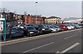
Newport railway station car park
Located between Godfrey Road and the western entrance http://www.geograph.org.uk/photo/3430149 to the railway station.
The Pay and Display car park, operated by National Car Parks Ltd, has space for 246 cars.
Image: © Jaggery
Taken: 5 Mar 2013
0.02 miles
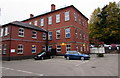
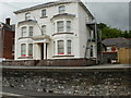
5

Platform office building, Newport
The 3-storey building is between Devon Place and Newport railway station.
Image: © Jaggery
Taken: 16 Oct 2015
0.02 miles
6

Ordnance Survey Cut Mark
This OS cut mark can be found on the wall of No38 Devon Place. It marks a point 18.416m above mean sea level.
Image: © Adrian Dust
Taken: 25 May 2015
0.02 miles
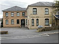
7
24 Gold Tops , Newport
Pagefield House, currently occupied by Haines Watts, Chartered Accountants.
Image: © Jaggery
Taken: 16 Aug 2009
0.03 miles
8
3 Gold Tops, Newport
Currently occupied by Purnells, Chartered Accountants & Licensed Insolvency Practitioners.
Image: © Jaggery
Taken: 16 Aug 2009
0.03 miles
9
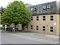
1 Gold Tops, Newport
Current occupiers include Midas Construction Ltd. http://www.geograph.org.uk/photo/1614700 for the view four months later, and an update on the occupancy.
Image: © Jaggery
Taken: 16 Aug 2009
0.03 miles
10
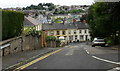
Looking down Stanley Road, Newport
Stanley Road is a candidate for the steepest road in Newport. It rises from 17.6 metres at its base in Devon Place to 28.8 metres at its junction with Gold Tops. The horizontal distance covered (as shown on a map ) is 59 metres, which gives a gradient of 1 in 5.3
As can be seen here, it joins Devon Place at a T junction, so in my younger, cycling, days it was one of the 'impossible' gradients, as a 'flying start' is not possible. It was not a hill to cycle down either, except with brakes engaged.
Fortunately, Stanley Road is not an essential link in the Newport road network.
A short detour via Pentonville avoids the excessive steepness. The view from the bottom http://www.geograph.org.uk/photo/1596720
Image: © Jaggery
Taken: 16 Aug 2009
0.03 miles