IMAGES TAKEN NEAR TO
St. Woolos Place, NEWPORT, NP20 4GQ
Introduction
This page details the photographs taken nearby to St. Woolos Place, NP20 4GQ by members of the Geograph project.
The Geograph project started in 2005 with the aim of publishing, organising and preserving representative images for every square kilometre of Great Britain, Ireland and the Isle of Man.

There are currently over 7.5m images from over14,400 individuals and you can help contribute to the project by visiting https://www.geograph.org.uk
Image Map
Images are licensed for reuse under creativecommons.org/licenses/by-sa/2.0
Notes
- Clicking on the map will re-center to the selected point.
- The higher the marker number, the further away the image location is from the centre of the postcode.
Image Listing (699 Images Found)
Images are licensed for reuse under creativecommons.org/licenses/by-sa/2.0
Image
Details
Distance
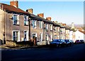
2
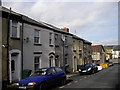
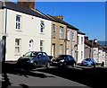
Row of eight houses, St Woolos Road, Newport
On the west side of St Woolos Road between St Julian Street and St Woolos Place.
Image: © Jaggery
Taken: 21 Nov 2015
0.02 miles
3
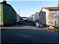
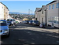
St Woolos Place, Newport
Dead-end street extending for 60 metres from St Woolos Road.
An old-style name sign on the corner wall on the right shows
ST WOOLLOS PLACE but the spelling Woolos is now generally used,
both for street names and the nearby cathedral. www.geograph.org.uk/photo/4747137
Image: © Jaggery
Taken: 21 Nov 2015
0.02 miles
4
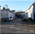
St Woolos Road parking regulations, Newport
In November 2015, the sign on the right, near the corner of St Woolos Place, shows no parking at any time to the left of the sign. On the right side of the sign, parking is allowed for up to 2 hours between 8am and 8pm Monday-Saturday. No return within 2 hours. The right-side restrictions do not apply to Y2 resident permit holders.
Image: © Jaggery
Taken: 21 Nov 2015
0.02 miles
5
Cars and houses at the southern end of St Woolos Road, Newport
Viewed from the corner of Clifton Road. The car on the right is near the corner of St Woolos Place.
Image: © Jaggery
Taken: 26 Jun 2018
0.02 miles
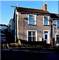
6
St Woolos Road, Newport
This is the southern end of St Woolos Road - the Clifton Road junction is behind the camera.
Ahead, St Woolos Road descends steeply northwards to St Mary Street.
Image: © Jaggery
Taken: 26 Jun 2018
0.02 miles
7
St Julian Street, Newport
Dead-end street extending for 90 metres from St Woolos Road.
A footpath at the far end of the street leads to the far end of adjacent streets.
Image: © Jaggery
Taken: 21 Nov 2015
0.03 miles
8
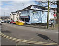
Former Hales Television shop, St Woolos Road, Newport
Viewed in March 2018. A full skip is outside the shop and a To Let board is on the wall.
Image: © Jaggery
Taken: 19 Mar 2018
0.03 miles
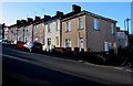
9
West side of St Woolos Road, Newport
Row of houses extending for 45 metres from the corner
of St Woolos Place on the left, to the corner of St Julian Street.
Image: © Jaggery
Taken: 21 Nov 2015
0.03 miles
10

Benchmark on wall of Edward Lane
Ordnance Survey cut mark benchmark on wall at rear of #30 York Place. The mark is described on the Bench Mark Database at http://www.bench-marks.org.uk/bm35083.
Image: © Roger Templeman
Taken: 5 Aug 2010
0.04 miles