IMAGES TAKEN NEAR TO
York Place, NEWPORT, NP20 4GB
Introduction
This page details the photographs taken nearby to York Place, NP20 4GB by members of the Geograph project.
The Geograph project started in 2005 with the aim of publishing, organising and preserving representative images for every square kilometre of Great Britain, Ireland and the Isle of Man.

There are currently over 7.5m images from over14,400 individuals and you can help contribute to the project by visiting https://www.geograph.org.uk
Image Map
Images are licensed for reuse under creativecommons.org/licenses/by-sa/2.0
Notes
- Clicking on the map will re-center to the selected point.
- The higher the marker number, the further away the image location is from the centre of the postcode.
Image Listing (612 Images Found)
Images are licensed for reuse under creativecommons.org/licenses/by-sa/2.0
Image
Details
Distance
1

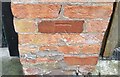
Benchmark on wall of Edward Lane
Ordnance Survey cut mark benchmark on wall at rear of #30 York Place. The mark is described on the Bench Mark Database at http://www.bench-marks.org.uk/bm35083.
Image: © Roger Templeman
Taken: 5 Aug 2010
0.02 miles
2
Ordnance Survey Cut Mark
This OS cut mark can be found on the wall junction on Edward Lane. It marks a point 55.090m above mean sea level.
Image: © Adrian Dust
Taken: 17 Jun 2018
0.02 miles
3

Spar and filling station, Stow Hill
Late August evening, the red sky providing a backdrop to the BP filling station and SPAR convenience store on Stow Hill.
Image: © Ian Paterson
Taken: 17 Aug 2010
0.02 miles
4
St Julian Street, Baneswell, Newport
Viewed from the corner of St Woolos Road.
http://www.geograph.org.uk/photo/2024674 for a view from the far end of the street.
Image: © Jaggery
Taken: 16 Nov 2009
0.02 miles
5

St Woolos Place, Newport
St Woolos Place is a cul-de-sac of 15 terraced houses on the west side of St Woolos Road. Viewed from the far end.
Image: © Jaggery
Taken: 21 Aug 2010
0.02 miles
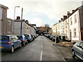
6

Looking up York Place, Newport
York Place climbs towards Stow Hill. The building on the right http://www.geograph.org.uk/photo/2025831 is Grade II listed.
Image: © Jaggery
Taken: 21 Aug 2010
0.02 miles
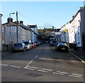
7

Corner of St Woolos Road and St Woolos Place, Newport
The dark green colour of the large corner house contrasts with the various shades of grey of neighbouring houses.
Image: © Jaggery
Taken: 22 Aug 2010
0.02 miles
8

Clifton Road houses, Newport
Houses on Clifton Road, between Stow Hill and St Woolos Road. The houses face St Woolos Cathedral. http://www.geograph.org.uk/photo/1257021
Image: © Jaggery
Taken: 22 Aug 2010
0.02 miles
9
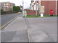
Newport: postbox № NP20 97, Stow Hill
This large postbox stands on the forecourt of a 24-hour filling station/general store. It was probably moved here from a little closer to the cathedral, since there used to be a post office along there and there is no box now outside the premises.
The box is emptied finally at 5:30pm on weekdays and at noon on Saturdays.
Image: © Chris Downer
Taken: 22 Feb 2009
0.02 miles
10
St Julian Street, Newport
Dead-end street extending for 90 metres from St Woolos Road.
A footpath at the far end of the street leads to the far end of adjacent streets.
Image: © Jaggery
Taken: 21 Nov 2015
0.02 miles