IMAGES TAKEN NEAR TO
Stow Park Avenue, NEWPORT, NP20 4FT
Introduction
This page details the photographs taken nearby to Stow Park Avenue, NP20 4FT by members of the Geograph project.
The Geograph project started in 2005 with the aim of publishing, organising and preserving representative images for every square kilometre of Great Britain, Ireland and the Isle of Man.

There are currently over 7.5m images from over14,400 individuals and you can help contribute to the project by visiting https://www.geograph.org.uk
Image Map
Images are licensed for reuse under creativecommons.org/licenses/by-sa/2.0
Notes
- Clicking on the map will re-center to the selected point.
- The higher the marker number, the further away the image location is from the centre of the postcode.
Image Listing (528 Images Found)
Images are licensed for reuse under creativecommons.org/licenses/by-sa/2.0
Image
Details
Distance
1
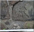
Ordnance Survey Cut Mark
This OS cut mark can be found on The Cottage, Stow Park Avenue. It marks a point 60.059m above mean sea level.
Image: © Adrian Dust
Taken: 17 Jun 2018
0.02 miles
3
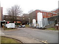
Southern entrance road to St Woolos Hospital, Newport
A road http://www.geograph.org.uk/photo/1473698 from Friars Road leads to the entrance, on the left, into the newer southern section of the hospital. An enclosed bridge, visible in the background, connects to the older northern part of the hospital. The white cylinders contain oxygen.
Image: © Jaggery
Taken: 23 Jan 2011
0.06 miles
4
Road to parking area, St Woolos Hospital, Newport
The road from the Friars Road hospital entrance http://www.geograph.org.uk/photo/1473698 leads to a parking area, out of shot on the left.
Image: © Jaggery
Taken: 6 Mar 2011
0.06 miles
5
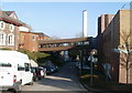
Sloping enclosed bridge connecting two halves of St Woolos Hospital
The bridge connects the older part of the hospital on the left with the newer Casnewydd Unit on the right. St Woolos Hospital is on a sloping site. The northern entrance from Stow Hill http://www.geograph.org.uk/photo/1628503 is at an elevation about 15 metres (50 feet) higher than the southern entrance http://www.geograph.org.uk/photo/1473698 from Friars Road.
Image: © Jaggery
Taken: 6 Mar 2011
0.06 miles
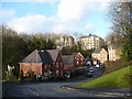
6
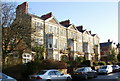
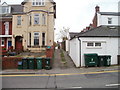
Stow Park Avenue, Newport
Houses on the east side of Stow Park Avenue, near the Stow Hill junction.
Image: © Jaggery
Taken: 20 Dec 2009
0.06 miles
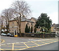
8
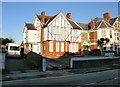
The Knoll Guesthouse, Newport
Located on the corner of Stow Hill and Stow Park Avenue, viewed from opposite Spring Lane.
Image: © Jaggery
Taken: 22 Nov 2010
0.06 miles
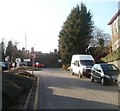
9
Spring Lane, Newport
Spring Lane runs for about 90 metres (100 yards) on the south side of Stow Hill.
Viewed from near the corner of Brynhyfryd Road and Stow Hill.
Image: © Jaggery
Taken: 22 Nov 2010
0.06 miles
10
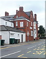
Belle View Park Care Home, Newport
Located at 11 Stow Park Avenue, on the corner of Stow Hill. The privately-owned care home (with nursing) accommodates 40 residents.
Image: © Jaggery
Taken: 22 Nov 2010
0.06 miles