1
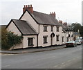
The Friars, Newport
Located at the corner of Friars Field and Friars Road, between St Woolos Hospital and the Royal Gwent Hospital. Built as a private dwelling house in the Victorian era, it is now a postgraduate medical and dental education centre.
Image: © Jaggery
Taken: 26 Nov 2009
0.02 miles
2
9-13 Friars Road, Newport
A short row of three houses on the east side of Friars Road, located between the turnings for Friars Court and Friars Field.
Image: © Jaggery
Taken: 27 Jan 2011
0.02 miles
3
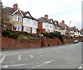
Houses on the west side of Friars Road, Newport
Viewed from the edge of The Friars. http://www.geograph.org.uk/photo/1596245 The houses are opposite these. http://www.geograph.org.uk/photo/2248624
Image: © Jaggery
Taken: 27 Jan 2011
0.02 miles
4
Newport : Friars Road houses near Belle Vue Lane
Viewed from the corner of Belle Vue Lane. The houses are opposite Belle Vue Park, adjacent to its northern entry lodge. http://www.geograph.org.uk/photo/1596268
Image: © Jaggery
Taken: 27 Jan 2011
0.02 miles
5
Abbots Mews, Newport
Cul-de-sac of 7 houses, built in 2001. Abbots Mews is on the east side of Friars Road, connecting to it via Friars Court.
Image: © Jaggery
Taken: 7 Feb 2011
0.02 miles
6
Grade II listed The Friars, Newport
Located on the corner of Friars Field and Friars Road, between St Woolos Hospital and the Royal Gwent Hospital. Built as a private dwelling house in the Victorian era, it is now a postgraduate medical and dental education centre.
Grade II listed in February 1980.
Image: © Jaggery
Taken: 3 Mar 2012
0.02 miles
7
Ordnance Survey Cut Mark
This OS cut mark can be found on The Friars road junction. It marks a point 48.046m above mean sea level.
Image: © Adrian Dust
Taken: 9 Jun 2018
0.03 miles
8
Belle Vue Park, closed (3)
The Friars Road entrance.
Image: © Robin Drayton
Taken: 15 Apr 2020
0.03 miles
9
Entrance gates, Belle Vue Park
There are two non public vehicular entrances to the park.
This is the Friars Road entrance.
The other one is in Cardiff Road http://www.geograph.org.uk/photo/515538 ,
Image: © Robin Drayton
Taken: 3 Nov 2012
0.04 miles
10
Belle Vue Park Lodge
The park has two lodges; this one being at the Friars Road entrance. The other is on Cardiff Road http://www.geograph.org.uk/photo/515538 .
Taken from the gardens that are adjacent to the pergola http://www.geograph.org.uk/photo/3213952 .
Image: © Robin Drayton
Taken: 19 Feb 2013
0.04 miles


