IMAGES TAKEN NEAR TO
Groves Road, NEWPORT, NP20 3SP
Introduction
This page details the photographs taken nearby to Groves Road, NP20 3SP by members of the Geograph project.
The Geograph project started in 2005 with the aim of publishing, organising and preserving representative images for every square kilometre of Great Britain, Ireland and the Isle of Man.

There are currently over 7.5m images from over14,400 individuals and you can help contribute to the project by visiting https://www.geograph.org.uk
Image Map
Images are licensed for reuse under creativecommons.org/licenses/by-sa/2.0
Notes
- Clicking on the map will re-center to the selected point.
- The higher the marker number, the further away the image location is from the centre of the postcode.
Image Listing (103 Images Found)
Images are licensed for reuse under creativecommons.org/licenses/by-sa/2.0
Image
Details
Distance
1
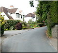
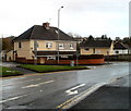
Glasllwch Lane houses, Newport
Many of the houses on Glasllwch Lane are set well back from the roadway, and shielded from it by hedges or other vegetation. These houses are an exception, in plain view at a bend in the lane near its NE end.
Image: © Jaggery
Taken: 21 Jul 2011
0.02 miles
2
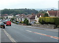
Glasllwch Crescent, B4591, Newport
The view west in the direction of junction 27, M4 motorway. The B4591 has several local names hereabouts. A few hundred metres behind the camera it is Risca Road. Soon after crossing above the M4, it is High Cross Road.
Image: © Jaggery
Taken: 21 Jul 2011
0.08 miles
3
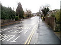
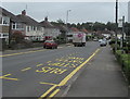
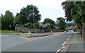
Northern end of Western Avenue, Newport
The view south along Western Avenue from the corner of Glasllwch Crescent.
The white letters on the road surface instruct drivers leaving Western Avenue to turn left. The message is reinforced by a pair of no right turn signs, out of shot behind the camera.
Image: © Jaggery
Taken: 18 Nov 2010
0.08 miles
4
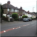
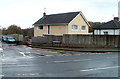
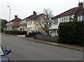
South side of Glasllwch Crescent, Newport
Semi-detached houses on the south side of the B4591 Glasllwch Crescent.
Ahead for M4 motorway junction 27.
Image: © Jaggery
Taken: 26 Jun 2019
0.09 miles
5
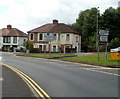
Eastern section of Glasllwch Crescent, Newport
Glasllwch Crescent is split in two by the course of the M4 motorway. These houses are at the western edge of the eastern section, adjacent to Brickyard Lane.
Image: © Jaggery
Taken: 18 Nov 2010
0.10 miles
6
Corner of Brickyard Lane, Newport
A Glasllwch Crescent house located on the corner of Brickyard Lane, opposite Western Avenue.
Image: © Jaggery
Taken: 18 Nov 2010
0.10 miles
7
Glasllwch Crescent bus stop, Newport
The stop on the north side of the B4591 Glasllwch Crescent is for buses to Newport city centre.
Image: © Jaggery
Taken: 26 Jun 2019
0.10 miles
8
Glasllwch Crescent houses near Western Avenue, Newport
Glasllwch Crescent is split in two by the course of the M4 motorway. These houses are between the motorway and the Western Avenue junction, out of shot beyond the left edge of the view.
Image: © Jaggery
Taken: 8 Aug 2011
0.11 miles
9
Glasllwch Crescent, Newport
The B4591 has various names in this area of Newport. Behind the camera, it is Risca Road. Ahead, it is Glasllwch Crescent, then High Cross Road, Cefn Road, and finally Risca Road again, near the western edge of Newport.
Image: © Jaggery
Taken: 25 Jul 2010
0.12 miles
10
Glasllwch Crescent semis, Newport
Semi-detached houses on the south side of the B4591 Glasllwch Crescent.
Image: © Jaggery
Taken: 26 Jun 2019
0.13 miles