IMAGES TAKEN NEAR TO
Glasllwch Crescent, NEWPORT, NP20 3SE
Introduction
This page details the photographs taken nearby to Glasllwch Crescent, NP20 3SE by members of the Geograph project.
The Geograph project started in 2005 with the aim of publishing, organising and preserving representative images for every square kilometre of Great Britain, Ireland and the Isle of Man.

There are currently over 7.5m images from over14,400 individuals and you can help contribute to the project by visiting https://www.geograph.org.uk
Image Map
Images are licensed for reuse under creativecommons.org/licenses/by-sa/2.0
Notes
- Clicking on the map will re-center to the selected point.
- The higher the marker number, the further away the image location is from the centre of the postcode.
Image Listing (87 Images Found)
Images are licensed for reuse under creativecommons.org/licenses/by-sa/2.0
Image
Details
Distance
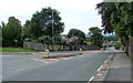
1
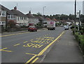
Glasllwch Crescent bus stop, Newport
The stop on the north side of the B4591 Glasllwch Crescent is for buses to Newport city centre.
Image: © Jaggery
Taken: 26 Jun 2019
0.01 miles
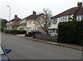
2
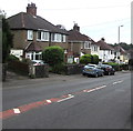
South side of Glasllwch Crescent, Newport
Semi-detached houses on the south side of the B4591 Glasllwch Crescent.
Ahead for M4 motorway junction 27.
Image: © Jaggery
Taken: 26 Jun 2019
0.03 miles
3
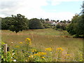
A view east from Brickyard Lane, Newport
Early August vegetation and foliage viewed looking towards houses in Glasllwch Crescent.
Image: © Jaggery
Taken: 8 Aug 2011
0.04 miles
4
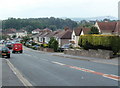
Glasllwch Crescent, B4591, Newport
The view west in the direction of junction 27, M4 motorway. The B4591 has several local names hereabouts. A few hundred metres behind the camera it is Risca Road. Soon after crossing above the M4, it is High Cross Road.
Image: © Jaggery
Taken: 21 Jul 2011
0.04 miles
5
Glasllwch Crescent semis, Newport
Semi-detached houses on the south side of the B4591 Glasllwch Crescent.
Image: © Jaggery
Taken: 26 Jun 2019
0.05 miles
6
Glasllwch Crescent, Newport
The B4591 has various names in this area of Newport. Behind the camera, it is Risca Road. Ahead, it is Glasllwch Crescent, then High Cross Road, Cefn Road, and finally Risca Road again, near the western edge of Newport.
Image: © Jaggery
Taken: 25 Jul 2010
0.05 miles
7
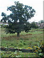
Oak in a field, Brickyard Lane, Newport
Viewed from Brickyard Lane looking towards Glasllwch Crescent.
Image: © Jaggery
Taken: 8 Aug 2011
0.07 miles
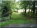
8
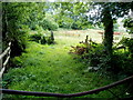
Field viewed across a bent bar, Brickyard Lane, Newport
Viewed from this http://www.geograph.org.uk/photo/3213074 gate.
Image: © Jaggery
Taken: 8 Aug 2011
0.07 miles
9
Bent top bar on a field gate, Brickyard Lane, Newport
I don't know how the bar became bent, but the cause was definitely not this contributor sitting on it...
Image: © Jaggery
Taken: 8 Aug 2011
0.08 miles
10
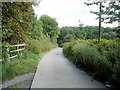
Brickyard Lane, Newport
The brickyard is long gone. The present-day Brickyard Lane has a rural feel, somewhat tempered by the presence of a motorway slip road at M4 motorway junction 27 on the other side of the hedges on the left. The lane leads to Beau Court Stud and Riding School.
Image: © Jaggery
Taken: 8 Aug 2011
0.09 miles